
Municipality El Tiemblo Elevation 689 m Population 4,301 (2014) Local time Wednesday 5:11 AM | Time zone CET (UTC+1) Area 75 km² | |
 | ||
Weather 7°C, Wind NW at 8 km/h, 83% Humidity | ||
El Tiemblo is a municipality located in the province of Ávila, Castile and León, Spain. According to the 2012 census (INE), the municipality has a population of 4,461 inhabitants, and covers an area of about 75 km2.
Contents
- Map of 05270 El Tiemblo C381vila Spain
- Location
- Climate
- Population
- Public schools
- Private religious school
- Architectural heritage
- References
Map of 05270 El Tiemblo, %C3%81vila, Spain
Location
El Tiemblo is located in the valley of the river Alberche, between the reservoirs of El Burguillo and of San Juan, next to the smaller reservoir of El Charco del Cura. The neighbouring municipalities are El Barraco, Cebreros, San Martin de Valdeiglesias, Casillas and Navahondilla.
El Tiemblo is on the southern slopes of the Sierra de Gredos mountain range. To the southeast is the Alto del Mirlo peak at 1,725 m above sea level; La Parra at 1,637 m, La Encinilla at 1,604 m.
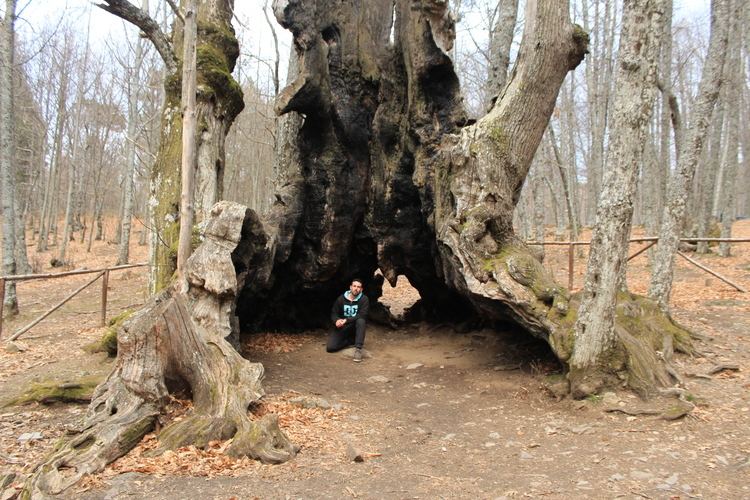
Part of the territory of the municipality of El Tiemblo forms part of the Valle de Iruelas Natural Park, which is home to a large colony of black vultures (Aegypius monachus).
Inside this natural park is the Castañar de El Tiemblo, a chestnut tree forest that contains trees that are several centuries old. The oldest one is known as El Abuelo (the grandfather) and is said to be over 500 years old.
Climate
El Tiemblo has a Mediterranean climate (temperate with hot dry summers) according to the Köppen classification.
Population
Apart from El Tiemblo itself, there are four other villages or hamlets in the municipality: La Atalaya, Cerro guisando, Poblado de El Burguillo and Puente Nuevo.
Public schools
Private religious school
“Santisima Trinidad” (kindergarten, primary and secondary)