
Elevation 490 m | Reference no. 486 Local time Tuesday 3:51 PM | |
 | ||
Weather 12°C, Wind W at 3 km/h, 51% Humidity Restaurants Poor Red's Bar‑B‑Q, The Main Street Buzz, Chicago Pizza & Burger | ||
El Dorado (Spanish for The golden; formerly Eldorado, Mud Spring, and Mud Springs), not to be confused with the nearby El Dorado Hills, is an unincorporated community in El Dorado County, California. It is located 4 miles (6.4 km) southwest of Placerville, at an elevation of 1608 feet (490 m). The population was 4,096 at the 2000 census. The town is registered as California Historical Landmark #486. The ZIP code is 95623. The community is inside area code 530.
Contents
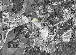
Map of El Dorado, Diamond Springs, CA 95623, USA
History
El Dorado, "The Gilded One", was first known as Mud Springs from the boggy quagmire the cattle and horses made of a nearby watering place. Originally an important camp on the old Carson Trail, by 1849-50 it had become the center of a mining district and the crossroads for freight and stagecoach lines. At the height of the rush its large gold production supported a population of several thousand. It was incorporated as the town of El Dorado in 1856.
The first post office in Mud Spring was opened in 1851, the name was changed to El Dorado in 1855. The town incorporated in 1855 and disincorporated in 1857.
Politics
In the state legislature, El Dorado is in the 1st Senate District, represented by Republican Ted Gaines, and the 5th Assembly District, represented by Republican Frank Bigelow.
Federally, El Dorado is in California's 4th congressional district, represented by Republican Tom McClintock.