
Elevation 2,458 m Mountain range Guadalupe Mountains | Prominence 87 m Easiest route Hiking | |
 | ||
Similar Guadalupe Peak, Bush Mountain, Hunter Peak, Shumard Peak, Emory Peak | ||
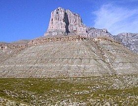
El Capitan is a peak in Culberson County, Texas, United States, within Guadalupe Mountains National Park. It is the eighth highest peak in Texas, and rises abruptly out of the Chihuahuan Desert floor; it is considered the "signature peak" of West Texas.
Map of El Capitan, Texas 79847, USA
El Capitan is the southern terminus of the Guadalupe escarpment, an ancient limestone reef that forms the present-day Guadalupe Mountains. El Capitan is guarded by cliffs on three sides, and those faces are rarely climbed due to the unstable condition of the rock and the sheer nature of the peak. Hikers can scramble up to the summit by first climbing to near the summit of Guadalupe Peak and scrambling down to the south to the Guadalupe Peak-El Capitan saddle, then up the backside of El Capitan.
Used as a signal peak for hundreds of years by travelers in the area, its sheer face is visible when approaching the Headquarters Visitor Center at Guadalupe Mountains National Park from both the south and the northeast.