
Country Argentina Time zone ART (UTC-3) Elevation 199 m | Demonym(s) calafateño/a CPA base Z9405 Local time Tuesday 7:33 PM | |
 | ||
Weather 13°C, Wind E at 6 km/h, 72% Humidity Points of interest Los Glaciares National, Reserva Laguna Nimez, museo ‑ centro de interpreta, Southern Spirit Lake Argentino, La Aldea de Gnomos | ||
El Calafate is a city in Patagonia, Argentina. It is situated in the southern border of Lake Argentino, in the southwest part of the Santa Cruz Province, about 320 km Northwest of Río Gallegos. The name of the city is derived from a little bush with yellow flowers and dark blue berries that is very common in Patagonia: the calafate (Berberis buxifolia); the word comes from the word "calafate", which is Spanish for "caulk".
Contents
- Map of El Calafate Santa Cruz Province Argentina
- Upsala glacier el calafate province of santa cruz patagonia argentina
- History
- Transport
- Population
- Wildlife
- Climate
- Attractions
- Interesting facts
- References
Map of El Calafate, Santa Cruz Province, Argentina
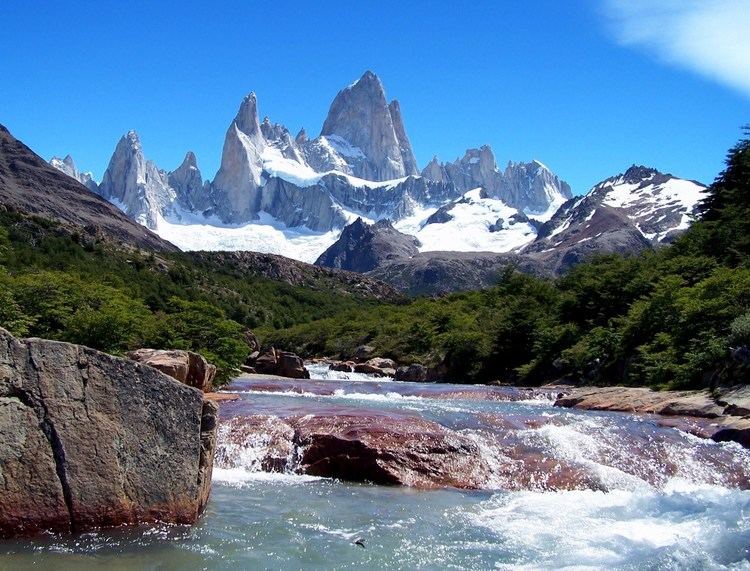
El Calafate is an important tourist destination as the hub to visit different parts of the Los Glaciares National Park, including the Perito Moreno Glacier and the Cerro Chaltén and Cerro Torre.
Upsala glacier el calafate province of santa cruz patagonia argentina
History
The history of El Calafate began in the first decades of the twentieth century. Originally, it was simply a sheltering place for wool traders. The town was officially founded in 1927 by the government of Argentina to promote settlement, but it was the creation of nearby Perito Moreno National Park in 1937 that sparked growth and the building of better road access.
Transport
The 220 kilometers separating Calafate from El Chaltén on the other side of the Lake Argentino in the national park are paved, as well as the 315 kilometres to Río Gallegos. Other distances are: to Bariloche 1400 km ; to Esquel 1108 km (some dirt road); Comodoro Rivadavia 959 km; Puerto Madryn 1388 km; Buenos Aires 2727 km; Ushuaia 863 km and in Chile Puerto Natales 362 km and Punta Arenas 605 km.
The town is served by El Calafate International Airport (IATA: FTE, ICAO: SAWC) located some 20 km east of the village.
Population
In the last census 6,143 permanent residents were counted (2001 census [INDEC]). This represents a 20.1% increase compared with the 1991 census. However, due to the expansion of tourism, the population was estimated at 20,000 people in 2014.
Wildlife
Flamingos are regularly visible from El Calafate congregating in the waters of Lago Argentino.
Climate
El Calafate experiences a cold semi-arid climate (Köppen BSk) with cool to warm, very dry summers and cool to cold, slightly wetter winters. The city's extremes of cold and heat are moderated by the influence of the very large lake (Lago Argentino). The waterfront of the city is located on a large shallow bay that is often frozen in the winter, allowing residents to practice ice skating. The highest temperature recorded was 30.7 °C (87.3 °F) while the lowest recorded temperature was −17.0 °C (1.4 °F) on July 27, 2016.
Attractions
El Calafate is the location of the Glaciarium, a museum that focuses on ice and glaciers, especially in the Southern Patagonian Ice Field.
Interesting facts
The gliding altitude record of 50,722 feet (15,460 m) was set near El Calafate on 30 August 2006 by Steve Fossett and Einar Enevoldson in their 'Perlan' high altitude research glider. This record has been certified by the Fédération Aéronautique Internationale.
The town was on the path of the total solar eclipse of July 11, 2010, occurring just before sunset. El Calafate was featured in the Top Gear Patagonia Special, in which the presenters drove from Bariloche to Ushuaia.