
Gaelic name Calum Cille Area rank 144 Lieutenancy area Outer Hebrides | OS grid reference NB385215 Highest elevation Creag Mhor 43 m Area 110 ha Council area Outer Hebrides | |
 | ||
Meaning of name island of Saint Columba | ||
Eilean Chaluim Chille (Gaelic: island of Saint Columba, Calum Cille) is an unpopulated island in the Outer Hebrides.
Contents
Map of Eilean Chaluim Chille, United Kingdom
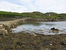
It lies off the east coast of Lewis at the mouth of Loch Erisort. At low tide Eilean Chaluim Chille is connected by a causeway to the mainland of Lewis at Crobeag.
History
At the southern end of the island lie the ruins of St Columba's Church. This was once an important centre of religion, being cited in a report of 1549 as the main place of worship for the parish of Lochs. There was probably a church there from about 800 AD, built by St Columba's followers. St Columba died on Iona in 597 AD. The cemetery was in use until 1878. Eilean Chaluim Chille is protected by Historic Scotland as an ancient monument.
References
Eilean Chaluim Chille Wikipedia(Text) CC BY-SA