
Isolation 1.12 km → Grimmberg Elevation 546 m Mountain range Harz | Parent range Harz Mountains Prominence 63 m | |
 | ||
Similar Großer Knollen, Auf dem Acker, Wurmberg | ||
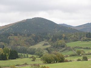
The Eichelnkopf is a 545.7 m (1,790 ft) high hill in the southwestern part of the Harz Mountains in the central German state of Lower Saxony.
Contents
Map of Eichelnkopf, 37447, Germany
GeographyEdit
The Eichelnkopf lies about 3.5 km (2.2 mi) east of Herzberg am Harz, about 3.5 km (2.2 mi) north of Scharzfeld and about 2.5 km (1.6 mi) southwest of the Großer Knollen. Its nearest neighbour is the Mittelecke. The hill is completely forested.
WalkingEdit
There is a trail that runs from the north and over the summit. The last 300 m (980 ft) below the summit, with an incline of up to 34%, is especially challenging for mountain bikers. On the south slope of the Eichelnkopf, a trail runs past the 300-year-old "Owl Oak" (Euleneiche).
GeologyEdit
On the eastern slopes is an isolated outcrop of dark argillaceous slate (Tonschiefer) from the Silurian period, which is one of the oldest rocks in the entire Harz.