
Elevation 2 m (7 ft) Area code 0595, 0596 Area 543.4 km² | Established 1 January 1979 Postcode 9979–9989, 9995–9999 Website www.eemsmond.nl Local time Tuesday 6:01 PM | |
 | ||
Weather 4°C, Wind E at 8 km/h, 81% Humidity Points of interest West Frisian Islands, Menkemaborg, Openluchtmuseum Het Hoogeland, Stichting Berlagehuis Usquert, Rensumaborg | ||
Eemsmond ( [ˈeːmsmɔnt]; English: Ems Mouth) is a municipality with a population of 15,864 in the north of the province of Groningen in the northeast of the Netherlands.
Contents
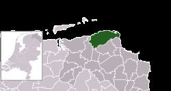
Map of Eemsmond, Netherlands
History
The municipality of Hefshuizen was established on 1 January 1979 by merging the municipalities of Uithuizen and Uithuizermeeden. On 1 January 1990, the municipalities of Kantens, Usquert, and Warffum were added. On 1 January 1992, the name of the municipality was changed from Hefshuizen to Eemsmond, which means Ems Mouth.
Geography
Eemsmond is located at 53°24′N 6°40′E in the north of the province of Groningen and in the northeast of the Netherlands.
The population centers in the municipality are: Eemshaven, Eppenhuizen, Kantens, Oldenzijl, Oosteinde, Oosternieland, Oudeschip, Roodeschool, Rottum, Startenhuizen, Stitswerd, Uithuizen, Uithuizermeeden, Usquert, Warffum, and Zandeweer.
To the north of Eemsmond is the North Sea. Part of the Wadden Sea, a UNESCO World Heritage Site since 2009, is located in the municipality, including the sandbank Simonszand and the uninhabited islands Rottumeroog, Rottumerplaat, and Zuiderduintjes. The northernmost point of the Netherlands is located at Rottumerplaat.
Culture
Eemsmond hosted the start of stage 4 at the 2013 Energiewacht Tour.
Government
Marijke van Beek of the Labour Party (PvdA) is mayor of Eemsmond.
Transportation
The Sauwerd–Roodeschool railway connects the railway stations Warffum, Usquert, Uithuizen, Uithuizermeeden, and Roodeschool to the Groningen railway station and the rest of the Dutch railway network.