
Country South Africa Established 1862 Area 41.4 km² Population 6,460 (2011) | Postal code (street) 9908 Local time Saturday 9:28 AM Area code 051 | |
 | ||
Weather 18°C, Wind N at 13 km/h, 48% Humidity | ||
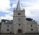
Edenburg is a small sheep and cattle ranching town situated about 80 kilometres (50 mi) south of Bloemfontein in the Free State province of South Africa. As of 2001, it had a population of 8,138.
Map of Edenburg, 9908, South Africa
Edenburg was proclaimed a town in 1863 and received municipal government in 1891.
The town is 85 km south-south-west of Bloemfontein. Laid out on the farm Rietfontein in 1862, it became a municipality in 1891. The name is said to be either of biblical origin or an adaptation of Edinburgh, name of the birthplace in Scotland of the Reverend Andrew Murray, for many years the only minister in the Orange Free State.
The N1 highway bypasses the town to the east, while the Port Elizabeth–Bloemfontein railway runs along its western edge.
References
Edenburg Wikipedia(Text) CC BY-SA