
Length 23 km Elevation change 200 m | Use Hiking Highest point 308 m | |
 | ||
Trailheads HertlingshausenDirmstein | ||
The Eckbach Mill Path (German: Eckbach-Mühlenwanderweg) is a footpath in the German state of Rhineland-Palatinate. It is 23 kilometres long and runs gently downhill along the Eckbach river through the Leiningerland in the northeast of the Palatinate region.
Contents
Course
The trail runs from west to east/northeast through the collective municipalities of Hettenleidelheim and Grünstadt-Land. It links nine villages and 23 of the original 35 water mills, running from the Palatinate Forest through the vineyards along the German Wine Road to the edge of the Upper Rhine Plain. The height difference between the start and end points (Hertlingshausen 308 metres, Dirmstein 108 metres) is 200 metres, the cumulative gain and loss over the generally gently descending route is only 250 metres, hence its difficulty is assessed as easy.
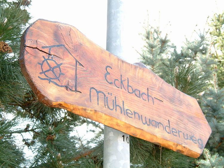
The route, which is accessible all year round, is marked by wooden signposts, made and maintained by voluntary workers. They bear the mill logo and the name Eckbach-Mühlenwanderweg. The logo depicts a house and waterwheel above a wavy line and was designed by Cosmas Kösters from Kirchheim in a school competition. The wavy line symbolizes the Eckbach, the stylized house with a water wheel represents a mill.
History
The path was created as a tourist attraction initiative of mill researcher, Wolfgang Niederhöfer, from Kleinkarlbach. On 12 October 1997 it was inaugurated by the minister president of Rhineland-Palatinate, Kurt Beck, in Großkarlbach, the village with the most surviving mills (six of seven). The suggestion made at the time to make the Großkarlbacher village mills a cultural monument and create the Leiningerland Mill Museum (Mühlenmuseum Leiningerland) was achieved in 2007.
Originally the route began by the Eckbachweiher pond and was only 19 kilometres long, but in 2000 it was extended by 4 kilometres upstream to the source of the Eckbach in Hertlingshausen.
Places and mills
- Hertlingshausen
- Altleiningen
- Neuleiningen-Tal
- Obermühle ("Upper Mill")
- Felsenmühle ("Rock Mill")
- Kleinkarlbach
- Walkmühle ("Waulk Mill")
- Wiesenmühle ("Pastureland Mill")
- Bann- and Backmühle
- Strohmühle ("Straw Mill")
- Schleifmühle ("Grinding Mill")
- Langmühle ("Long Mill")
- Kirchheim an der Weinstraße
- Kandelmühle or Oligmühle
- Eselsmühle ("Donkey Mill")
- Kochsche Mühle (locally known as the Gräfliche Leininger Mühle, "Leiningen Comital Mill")
- Bissersheim
- Bruchmühle
- Haldmühle ("Mill in the Hollow")
- Bergmühle ("Hill Mill")
- Großkarlbach
- Mühle am Weiher ("Mill by the Pond")
- Schlossmühle
- Rheinmühle ("Rhine Mill")
- Village mills
- Pappelmühle ("Poplar Mill")
- Heckmühle
- Laumersheim
- Weidenmühle ("Meadow Mill")
- Hornungsmühle
- Dirmstein
- Spormühle