
Admin. region Oberfranken Municipal assoc. Ebermannstadt Area 49.97 km² Local time Friday 6:31 PM Administrative region Upper Franconia | District Forchheim Elevation 292 m (958 ft) Population 6,826 (31 Dec 2008) Dialling code 09194 | |
 | ||
Weather 7°C, Wind NW at 8 km/h, 54% Humidity | ||
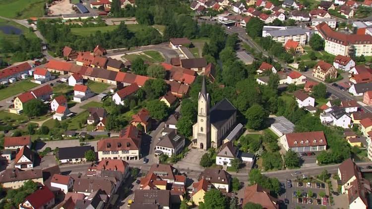
Ebermannstadt is a town in the district of Forchheim, in Bavaria, Germany. It is situated 10 km northeast of Forchheim and 25 km southeast of Bamberg.
Contents
- Map of Ebermannstadt Germany
- Districts
- History
- Chronology
- Tourism
- Buildings
- Economy
- Personalities
- References
Map of Ebermannstadt, Germany
Districts
History
The place on which Ebermannstadt is located today was already named imperial "villa Ebermarstad" in 981. At one point later it became the possession of the Schlüsselberger family. In 1430, the Hussites destroyed the place. Again, Ebermannstadt faced destructions during the Second Margrave War in 1552, the Thirty Years' War and finally in 1796 when the French army passed through the town. Albrecht Dürer stayed in Ebermannstadt in 1515 and painted an oil-painting of the town.
Chronology
531 Thuringian foundation, Location of an "Ebermar"981 First documented record of "Ebermarestad"; Ebermannstadt was part of St. Peter Monastery in Aschaffenburg1194 Record of Thimo and Cunradus de Ebermarstatt1200 The new owner of Ebermannstadt were the Schlüsselberg1308 Record of a church in Ebermannstadt1323 Ebermannstadt became market town during the reign of Louis IV1349 Partitioning of the Schlüsselberg possessions1390 Ebermannstadt is transferred to the Hochstift Bamberg1430 Hussites burn down Ebermannstadt1469 Ebermannstadt becomes an independent parish1510 Beer war with Pretzfeld for the right to brew1552 / 1553 Margrave Albrecht Alcibiades von Brandenburg-Kulmbach army destroys the town during the Second Margrave War1633 The Swedish army occupies the town during the Thirty Years' War1748 Birth of Friedrich Theileraround 1750: Principal Frantz Melchior Freytag writes the "Ebermannstädter Liederhandschrift"1756-1763 Quartering of Prussian soldiers during the Seven Years' War1772 Birth of Johann Georg Lahner in Gasseldorf1796 - 1815 Occupation by the French army during the French Revolutionary Wars1803 Secularization, Ebermannstadt becomes part of Bavaria1862 Foundation of the county of Ebermannstadt1891 Inauguration of the railroad line between Forchheim and Ebermannstadt1903 Electricity power station1907 District hospital1909 Flood1915 Opening of the railroad line to Heiligenstadt1922 Opening of the railroad line Gasseldorf - Muggendorf (later extended to Behringersmühle)1922 - 1923 Construction of the water conduit1939 Annexation of Breitenbach1941 Feuerstein Castle was used as laboratory for high frequency engineering1945 Local elections in Wohlmuthshüll1952 Airport for gliders1954 Construction of a Realschule1960 Suspension of passenger traffic on the train line to Heiligenstadt1961 Protestant Emmaus Church1965 Outdoor swimming-pool1970 Twin-city Chantonnay; flood1970 - 1974 Construction of the Gymnasium Fränkische Schweiz (high school)1971 Annexation of Gasseldorf and Niedermirsberg, Rüssenbach and Neuses-Poxstall1972 Dissolution of the county of Ebermannstadt, Annexation of Wohlmuthshüll and Buckenreuth1976 Suspension of train traffic between Ebermannstadt and Behringersmühle1978 Annexation of Eschlipp and Kanndorf, Formation of the administrative collectivity Ebermannstadt1979 Landslide near Eschlipp1981 Ceremony "One Thousand Years of Ebermannstadt"; Inception of scheduled train traffic of the steam railroad as a tourist attraction1994 Elevation to "Possible Middle Center"1999 Observatory FeuersteinTourism
Ebermannstadt is a state-approved resort town with an open-air swimming pool, campground in the district of Rothenbühl, golf course in the district of Kanndorf and a sport airfield on top of the Feuerstein.
During clear nights, there are guided tours at the Observatory Feuerstein. Thanks to the excellent conditions, it is possible to get a very good view of the universe.
Buildings
The most important sacred buildings of the town are the Maria Chapel and the neoroman Nicholas Church. Old Franconian timbered buildings are located near the market place with Maria Well. Landmark of the town is the scoop wheel from 1606 on the Wiesent. Feuerstein Castle, which was built only in 1941 in the style of Franconian castles, stands out above the town.
Economy
The largest companies in Ebermannstadt are