
Elevation 663 m (2,175 ft) Country Germany | Length 12 km (7.5 mi) District Olpe | |
 | ||
Similar Nordhelle, Biggesee, Rothaar Mountains, Arnsberg Forest Nature P, Homert | ||
Das ebbegebirge the ebbe mountains germany
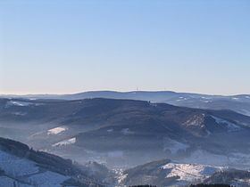
The Ebbe Mountains (German: Ebbegebirge) or Ebbe form a range of uplands up to 663.3 m above sea level (NN) high in the German state of North Rhine-Westphalia. They have given their name to the Ebbe Mountain Nature Park and are part of the Süder Uplands within the Rhine Massif.
Contents
- Das ebbegebirge the ebbe mountains germany
- Map of Ebbegebirge 58540 Meinerzhagen Germany
- LocationEdit
- HillsEdit
- Rivers and lakesEdit
- References
Map of Ebbegebirge, 58540 Meinerzhagen, Germany
LocationEdit
The Ebbe lies in the Sauerland in the districts of Märkischer Kreis and Olpe. It stretches between Herscheid and Plettenberg (outside the area) in the north, Attendorn and Finnentrop (outside the area) in the east, the Biggesee in the south and Kierspe and Meinerzhagen in the west, where the Ebbe Hills are surrounded by the Ebbe Hills Nature Park. It is grazed by the A 45 motorway in the west.
HillsEdit
The highest elevation in the Ebbe Mountains is the Nordhelle (663.3 m above NN) between Valbert and Herscheid. Other notable hills are the: Rehberg (645.9 m), Rüenhardt (636.0 m), Waldberg (ca. 635 m), Rothenstein (ca. 600 m), Der Griesing (552,6 m), Homert (538,3 m) and Kahler Kopf (540.1 m).
Rivers and lakesEdit
The following rivers rise in the Ebbe or around its edges: the Bruchbach, Else, Fürwigge, Ihne, Lister, Oesterbach, Verse and Volme. Within the Ebbe and its foothills are the Ahaus Reservoir, the Biggesee and the Fürwigge, Jubach, Lister, Oester and Verse Dams.