
Area 51,476 km² | Population 1.593 million (2010) | |
 | ||
Chipata eastern province zambia
Eastern Province is one of Zambia's ten provinces. The province lies between the Luangwa River and borders with Malawi to the east and Mozambique to the south, from Isoka in the northeast to the north of Luangwa in the south. The provincial capital is Chipata. Eastern province has an area of 51,476 km2 (19,875 sq mi), locally shares border with three other provinces of the country and is divided into eleven districts.
Contents
- Chipata eastern province zambia
- Map of Eastern Province Zambia
- History
- Geography
- Demographics
- Culture and wildlife parks
- Administration
- Economy health and education
- References
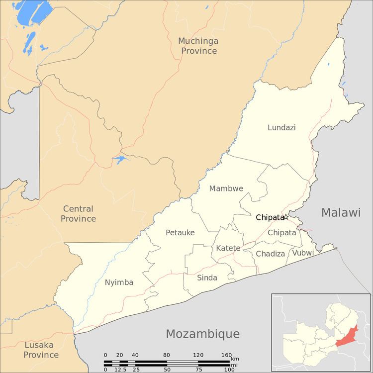
Map of Eastern Province, Zambia
As per the 2010 Zambian census, Eastern Province had a population of 1,592,661, accounting to 12.16% of the total Zambian population. The sex ratio was 1,030 for every 1,000 males. As of 2010, Chewa was the largest community in the region with 39.7 per cent of the total population and Chewa was the most widely spoken language with 34.6 per cent speaking it. On the tourism front, the province has four national parks, while the Nc'wala festival celebrated in Chipata District by the Ngoni tribe during February is the most prominent festival in the province. Agriculture is the major occupation in the province which accounts for 20.41 per cent of the total area cultivated in Zambia. The province accounted for 19.61 per cent of the total agricultural production in the country with sunflower being the major crop. Chipata Airport and Mfuwe Airport are the two airports in the province.
History
The history of the province is centered around the Chewa people who under the rule of Kalonga Gawa Undi established a vast empire extending to modern day Central Malawi and the northeastern part of Tete Province in Mozambique. The chieftains of the empire exercised control over the territory in modern times. The most notable of them was Kalonga Gawa Undi X, whose regime started in 1954. By 1957, he joined Harry Mwaanga Nkumbula's political party that supported the British Colonial Empire. By the time he completed his European tour and returned to his province, nationalism had almost spread in the entire province. To avoid uprising, periodic fatalities and loyalty he enjoyed among masses, he supported the nationalist movement. After the independence of Zambia, during the 1960s, some of the districts in the province had unprecedented growth in infrastructure and agriculture. However, the growth of the province was terminated along with that of the country due falling copper prices.
As of 2010, Chewa was the largest community in the region with 39.7 per cent population and Chewa was the widely spoken language in Eastern province with 34.6 per cent speaking it. The province was claimed as a part of Malawi in 1968 by the then Malawian President Dr. Hastings Kamazu Banda who was a supporter of the apartheid in South Africa against the wishes of Organization of African Unity (OAU). The then Zambian president Kenneth Kaunda openly asked Malawi to go on war with Zambia to claim the province and also affirmed that Zambia would not have trade relations with Malawi until the claim on territory was withdrawn. The expansionist ambition of Malawi was discontinued and the Eastern Province remained with Zambia.
Geography
The south-east corner of the province borders Malawi to its east and Mozambique to its south. Luangwa Valley rifting the highlands dividing Zambia and Malawi, is located in the region. A small portion of Nyika Plateau above Lake Nyasa is located in the northern portion of the province. Chipata is the most developed city in the province and the fifth most developed in the nation, followed by Lundazi and Petauke. The province is bordered by Muchinga Province to the north-west and Central Province and Lusaka Province to the south-west. There are isolated hills on the eastern border, some of which raise to a height of 6,000 ft (1,800 m) to 7,000 ft (2,100 m). The province, like seven other provinces except for Luapala and Northern provinces, lies in the watershed region between Congo and Zambezi river systems.
Demographics
As per the 2010 Zambian census, Eastern Province had a population of 1,592,661 accounting to 12.16 per cent of the total Zambian population of 13,092,666. There were 784,680 males and 807,981 females, making the sex ratio to 1,030 for every 1,000 males, compared to the national average of 1,028. The literacy rate stood at 54.40 per cent against a national average of 70.2 per cent. The rural population constituted 87.42 per cent, while the urban population was 12.58 per cent. The total area of the province was 51,476 km2 and the population density was 30.90 per km2. The population density during 2000 Zambian census stood at 17.8. The decadal population growth of the province was 2.60 per cent. The province recorded the highest rural population of 1,392,338 in 2010 among all provinces in the country. The lowest median age of 20.1 years was recorded in the province as of 2010. The median age in the province at the time of marriage was 20.1. The average household size was 5.2, with the families headed by females being 4.3 and 5.5 for families headed by men. The total eligible voters in the province constituted 60.30 per cent. The unemployment rate of the province was 8.80 per cent. The total fertility rate was 6.6, complete birth rate was 6.3, crude birth rate was 38.0, child women population at birth was 819, general fertility rate was 168, gross reproduction rate was 2.6 and net reproduction rate was 1.8. The total labour force constituted 58.70 per cent of the total population. Out of the labour force 67.4 per cent were men and 50.7 per cent were women. The annual growth rate of labour force was 1.8 per cent. Bemba was the most spoken language with 60.00 per cent speaking it. The total population in the province with the condition Albinism stood at 3,225. The life expectancy at birth stood at 46 compared to the national average of 51.
Culture and wildlife parks
The Luangwa Valley in Eastern Province has one of the best managed wild life areas in Zambia. South Luangwa National Park (although most of it lies outside the province, its management and the only public road access is from the province), North Luangwa National Park in Northern Province, Luambe National Park and Lukusuzi National Park are the major national parks in Eastern province. Game management areas cover most of the Luangwa Valley outside the national parks, and many animals migrate through the Province between the valley and game reserves in the highlands of neighbouring Malawi.
The Nc'wala festival celebrated in Chipata District by Ngoni tribe during February, Kulamba festival celebrated in Katete District by Chewa tribe during August, Kulonga festival celebrated in Lundazi District by Tumbuka tribe during August, Malaila festival celebrated in Mambwe District by Kunda tribe during October, Zengani festival celebrated in Lundazi District by Tumbuka tribe during October, Tuwimba festival celebrated in Petauke District by Nsenga tribe during October are the major festivals in the province. Kulamba Ceremony is the national gathering of Chewa in Zambia, Mosambique and Malawi. The Chewa chiefs pay homage to their king Kalonga Gawa Undi. Historically, the people petitioned to the king their troubles, while in modern times the chieftains inform their issues to the government. The festival originated during the 15th century. N'cwala is the annual gathering of the Ngoni tribe and is also dubbed as first fruits ceremony. It is held during the last week of February to the first week of March for three days. The members of the tribe and onlookers attend the event in thousands and arrive at Mutenguleni villages near the city of Chipata.
Administration
Provincial administration in Zambia is set up purely for administrative purposes. The province is headed by a minister appointed by the President and there are ministries of the central government for each province. The administrative head of the province is the Permanent Secretary, appointed by the President. There are a Deputy Permanent Secretary, heads of government departments and civil servants at the provincial level. Eastern Province is divided into nine districts as follows: Chadiza District, Chipata District, Katete District, Lundazi District, Mambwe District, Nyimba District, Petauke District, Sinda District and Vubwi District. All the district headquarters are the same as the district names. There are nine councils in the province, each headed by an elected representative, called councillor. Each councillor holds the office for three years. The administrative staff of the council is selected based on Local Government Service Commission from within or outside the district. The office of the provincial government is located in each of the district headquarters and has provincial local government officers and auditors. Each council is responsible for raising and collecting local taxes, and the budgets of the council are audited and submitted every year after the annual budget. The elected members of the council do not draw salaries, but are paid allowances from the council. Eastern Province is a predominantly rural area and hence there are no city or municipal councils. The government stipulates 63 different functions for the councils with the majority of them being infrastructure management and local administration. Councils are mandated to maintain each of their community centres, zoos, local parks, drainage system, playgrounds, cemeteries, caravan sites, libraries, museums and art galleries. They also work along with specific government departments for helping in agriculture, conservation of natural resources, postal service, establishing and maintaining hospitals, schools and colleges. The councils prepare schemes that encourage community participation. Chama District from the province was aligned to the newly created Muchinga Province in 2011.
Economy, health and education
As of 2004, the province had 861 basic schools, 41 high schools and the number of school children out of school in ages between 7 and 15 stood at 861. The unemployment rate was 6 per cent and the general unemployment rate for youth stood at 12 per cent as of 2008. The province had 36 doctors as of 2005. There were 447 Malaria incidence for every 1,000 people in the province as of 2005 and there were 9,338 AIDS death as of 2010. As of 2010, the province had the lowest literacy rate of 54.4 per cent among all provinces in the country.
The total area of crops planted during the year 2014 in the province was 387,273.09 hectares which constituted 20.41 per cent of the total area cultivated in Zambia. The net production stood at 799,026 metric tonnes, which formed 19.61 per cent of the total agricultural production in the country. Sunflower was the major crop in the province with 24,053 metric tonnes, constituting 70.20 per cent of the national output.
Chipata Airport and Mfuwe Airport are the two airports in the province.