
Population 5,598 (2011 census) Area 200 ha | Postcode(s) 4169 Postal code 4169 | |
 | ||
Location 2.5 km (2 mi) SE of Brisbane CBD LGA(s) City of Brisbane(East Brisbane Ward) | ||
East Brisbane is an inner suburb of Brisbane, Australia, located 2.5 kilometres (1.6 mi) south-east of the CBD. It is mostly residential, with some small commercial areas, and has many original Queenslander houses.
Contents
- Map of East Brisbane QLD 4169 Australia
- History
- Geography
- Demographics
- Landmarks
- Heritage listings
- Sport
- Transport
- Notable people
- References
Map of East Brisbane QLD 4169, Australia
History
The significant housing areas in East Brisbane were founded during the Brisbane property boom of the 1880s. For example, one such development was the Heathfield Estate, which was released in 1886.
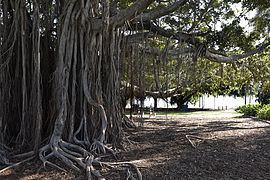
Mowbray Park, a large riverside park, was until the 1930s, the site of a public swimming pool built into the river.
Until 13 April 1969 electric trams operated by the Brisbane City Council served the suburb, running along Stanley Street from Woolloongabba, into Lisburn, Elfin and Latrobe Street and thence into Lytton Road, and on to Bulimba. Trolley-buses, also operated by the City Council operated along Stanley Street until March
Geography
East Brisbane is bounded by the Brisbane River to the north, Norman Park to the east, Coorparoo to the south-east, Woolloongabba to the south-west, and Kangaroo Point to the north-west. The border between Norman Park and most of Coorparoo follows Norman Creek.
Major roads include Lytton Road, Wellington Road, and Latrobe Street in the north, and Vulture Street and Stanley Street in the south of the suburb. The eastern side of the suburb rises to a small hill with some views over Woolloongabba and the CBD and falls away to Norman Creek.
Demographics
The 2011 Census recorded 5,598 residents in East Brisbane, of whom 54.9% were male and 45.1% were female. The median age of the population was 31; six years younger than the Australian median. 61.3% of people living in East Brisbane were born in Australia, compared to the national average of 69.8%. The other most common countries of birth were New Zealand (4.5%), England (3.1%), India (2.1%), South Korea (1.4%), and Ireland (0.9%). 72.5% of people only spoke English at home, while the next most commonly spoken languages were Mandarin (1.4%), Korean (1.3%), Italian (1%), Greek (1%), and Cantonese (0.9%). The most common religious affiliation was 'No Religion' (26.6%), followed by Catholic (23%), Anglican (15%), Uniting Church (3.8%) and Eastern Orthodox (2.3%).
Landmarks
Major landmarks in East Brisbane include Mowbray Park, Heath Park, and Anglican Church Grammar School.
Heritage listings
East Brisbane has a number of heritage-listed sites, including:
Sport
The suburb is home to Eastern Suburbs FC, who play at Heath Park in the Brisbane Premier League.
Transport
Public transport to the suburb is now predominantly provided by regular bus services and frequent CityCat services, which leave from Mowbray Park. The suburb is also an easy walk from the Woolloongabba bus station.