
 | ||
An earthquake warning system is a system of accelerometers, seismometers, communication, computers, and alarms that is devised for regional notification of a substantial earthquake while it is in progress. This is not the same as earthquake prediction, which is currently incapable of producing decisive event warnings.
Contents
Time lag and wave projection
An earthquake is caused by the release of stored elastic strain energy during rapid sliding along a fault. The sliding will start at some location and progress away from this hypocenter in each direction along the fault surface. The speed of the progression of this fault tear is slower than and distinct from the speed of the resultant pressure and shear waves, with the pressure wave traveling faster than the shear wave. The pressure wave will generate an abrupt shock while the shear waves can generate a periodic motion (at about 1 Hz) that is the most destructive in its effect upon structures, particularly buildings that have a similar resonant period, typically buildings around eight floors in height. These waves will be strongest at the ends of the slippage, and may project destructive waves well beyond the fault failure. The intensity of such remote effects are highly dependent upon local soils conditions within the region and these effects are considered in constructing a computer model of the region that determines appropriate responses to specific events.
Transit safety
Such systems are currently implemented to determine appropriate real-time response to an event in determining train operator response for urban rail systems such as BART (Bay Area Rapid Transit). The appropriate response will be highly dependent upon the warning time, the local right–of–way conditions, and the current speed of the train.
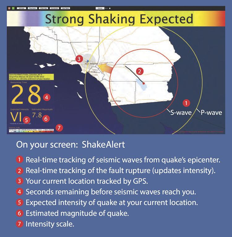
Deployment
As of 2016, Japan and Taiwan are two countries with comprehensive nationwide earthquake early warning systems. Other countries and regions have limited deployment of earthquake warning systems, including Mexico (installed to issue alerts to Mexico City primarily), limited regions of Romania (the Basarab bridge in Bucharest) and parts of the United States. The earliest automated earthquake pre-detection systems were installed in the 1990s, for instance in California the Calistoga fire station's system which can automatically trigger a citywide siren to alert the entire area's residents. While many of these efforts are governmental, several private companies also manufacturer earthquake early warning systems to protect infrastructure such as elevators, gas lines and fire stations.
Japan's Earthquake Early Warning system was put to practical use in 2006. Its scheme to warn the general public was installed on October 1, 2007. It was modeled partly on the Urgent Earthquake Detection and Alarm System (UrEDAS) of Japan Railways, which was designed to enable automatic braking of bullet trains.
In 2009, an early warning system called ShakeAlarm was installed and commissioned in Vancouver British Columbia Canada. It was placed to protect a piece of critical transportation infrastructure called the George Massey Tunnel, which connects north and south banks of the Fraser River. In this application the system automatically closes the gates at the tunnel entrances if there is a dangerous seismic event inbound. The success and the reliability of the system was such that as of 2015 there have been several additional installations on the West coast of Canada and the United States, and there are more being planned.
In January 2013, Francesco Finazzi of the University of Bergamo started the Earthquake Network research project which aims at developing and maintaining a crowdsourced earthquake warning system based on smartphone networks. Smartphones are used to detect the ground shaking induced by an earthquake and a warning is issued as soon as an earthquake is detected. People living at a higher distance from the epicenter and the detection point may be alerted before they are reached by the damaging waves of the earthquake. People can take part in the project installing the Android application "Earthquake Network" which is also required to receive the alerts.
In December 2014, United States Congress approved a $5 million allocation as part of the Consolidated Appropriations Act, 2014 in order to expand funding for development of the system.
The USGS has investigated collaboration with the social networking site Twitter to allow for more rapid construction of ShakeMaps. As of May 2015, USGS began testing an earthquake early warning app. QuakeAlert was developed by Early Warning Labs in partnership USGS.
In July 2015, the USGS awarded $4 million in funding to the Berkeley Seismological Laboratory, the California Institute of Technology and the University of Washington, to turn the current ShakeAlert early warning prototype into a more robust system that could be used by "cities, industries, utilities and transportation networks in California, Oregon and Washington".
Gravimetric data from the 2011 Tōhoku earthquake has been used to create a model for increased warning time compared to seismic models, as gravity fields travel faster than seismic waves.