
Length 2560 km | ||
 | ||
Location Europe: Netherlands, Germany, Poland Trailheads Scheveningen in The Hague; Ogrodniki on the border of Poland and Lithuania Use Hiking; large parts can be done on bicycle and horseback Highest point Harz mountains, 514 m (1,686 ft) Lowest point Rijnsaterswoude, −5 m (−16 ft) Designation European long-distance paths | ||
The E11 European long distance path or E11 path is one of the European long-distance paths, running 2560 km (about 1600 miles) west-east from The Hague in the Netherlands through Germany and Poland to the Lithuanian border. It starts in Scheveningen, a fishing community, commercial harbor and spa in The Hague on the Dutch coast of the North Sea. As there are no rambling organizations from Lithuania, Latvia or Russia participating in the European Ramblers' Association, it is unlikely that the E11 will be extended to reach Saint Petersburg or Moscow, as was foreseen originally.
Contents
- Geology and biology
- History
- E11 in The Netherlands 355 km
- E11 in Germany 996 km
- Tddenweg and Wittekindsweg 205 km
- Eastern Lower Saxony and Harz Mountains 186 km
- Harz Mountains and Saxony Anhalt 244 km
- Brandenburg and Berlin 348 km
- E11 in Poland 1177 km
- Oder bridge Midzyrzecz 141 km
- Midzyrzecz Pozna Kiekrz 133 km
- E11 through Pozna 33 km
- Pozna Zieliniec Gniezno 55 km
- Gniezno Toru 136 km
- Toru Brodnica 87 km
- Brodnica Olsztyn 237 km
- Olsztyn Godap 243 km
- Godap Lithuanian border 144 km
- References
The E11 is one of three European long distance paths running East from the Benelux to Eastern Poland. In the North, following the German and Polish coasts of North Sea and Baltic Sea, the E9 offers a variety of polders, sandy beaches, dunes and commercial harbors. More to the South, the E3 crosses through the long range of medium-sized mountains that links the mainly Belgian Ardennes to the Carpathian Mountains. The E11 takes an intermediate course through the rolling lowlands of Northern Germany and Poland. Nowhere does it touch a sea (not even the North Sea, as E11 starts in Scheveningen behind the first rows of buildings!), but it passes a single medium-sized mountain range, the Harz Mountains in the center of Germany. European long distance footpaths are strictly developed as hiking trails, but almost all of E11 can be travelled on a saddle - be it on a horse or a bicycle.
This article presents an encyclopedic overview of the trail. Detailed information about the routing is found in WikiVoyage. Links to detailed information about the townships along E11 are found in a special group of references at the bottom of this article.
Geology and biology
Most of the (original, pre-human) landscape along E11 was formed in the last 14,000 years, i.e. in the current Holocene or warmer period since the last ice age. The melting ice in Northern Europe caused huge rivers to carve out wide valleys, whilst the sea level rose significantly and flooded low land. It is known that the river Thames in England was once a tributary of the river Rhine on the continent; Britain was then not separated from the continent by the North Sea. In what is now known as the Netherlands and in the plains of (now) Northern Germany and Poland, rivers began to flow to carry the melted ice towards what became the Baltic Sea (itself also a result of the rising sea level) or the North Sea. These areas are now characterized by low-lying land, marshes, sandy old dunes (now stationary hills) alternating with older layers of peat.
From the Dutch and German border to the Harz, however, E11 passes through a different and much older geological area. It consists of a range of low mountain ridges (such as the Wiehen Hills and the Wesergebirge), created almost 100 million years ago from marine sediments which started to rise. The Harz mountains themselves are even much older (about 300 million years according to academic estimates) and stem from a variety of complicated geological processes. After the Harz, E11 drops back to the estuaries of the rivers in the plains.
Large parts of the E11 cross through forests, for which sometimes considerable detours are made. Open scenery is found in small parts of The Netherlands as well as in Eastern Germany and around the Polish city of Poznań. Nevertheless, the E11 links some interesting cities, such as The Hague, Amersfoort, Deventer, Osnabruck, Goslar, Luther's Wittenberg, Berlin, Frankfurt (Oder), Poznań, Gniezno, Toruń, Olsztyn, Lidzbark Warmiński and Kętrzyn. Lakes and rivers are not uncommon along the trail. The trail can be walked at any time of year, but the Polish winter is long, with a lot of snow. The highest point of E11 is 514 meters on the slopes of the Harz Mountains, whereas the lowest point is slightly under sea level in one of the polders in the West of The Netherlands.
Apart from getting lost in the vast Polish forests, there seem to be few hazards other than the occasional wild boar or gray wolf, or even a rare Eurasian lynx. It is only at the end of a severe winter season, when the animals are hungry, that extra care must be taken. In the summer, one might tread on a poisonous adder and in any season one might be bitten by a rabies infected mammal. The one really big danger, however, is the almost invisible tick as it may be infected with tick-borne diseases, especially Lyme disease and tick-borne meningoencephalitis.
History
In a sense, E11 is the oldest European footpath among the ERA network. There is archeological evidence that messengers and traders followed the range of low hills in what is now Northern Germany, thousands of years ago. Especially after the Middle Ages, the route became a backbone of East-West trade. Pedlars and other travelers preferred the dry and sandy ridge to the swamps to the North and South of it. At present, ramblers feel the same for a different reason: the forested hilltops are more pleasant to walk in than the congested lower areas.
From 1970, a regional hiking trail in Germany was gradually extended into The Netherlands until in 1980 the twin cities Haarlem and Osnabruck could present an ongoing international long distance path from West of Amsterdam to the then internal German border in the Harz Mountains. After the fall of the Berlin Wall in 1989 and the unification of Germany in 1990, the need was felt to extend the trail to the East on a partially new course, partially making use of existing trails in the former East Germany.
Parallel to the extension of the European Union to the East, the E11 was extended over the existing network of Polish local and regional hiking trails. The extension of the E11 to Moscow through Lithuania and Latvia has not so far been possible, due to the absence of rambling organizations in the three countries involved.
E11 in The Netherlands (355 km)
The Dutch section of E11 is known as the Marskramerpad ("Peddlers Way"), paying tribute to those who walked through the centuries along the same track. The Marskramerpad links Scheveningen in The Hague over 368 kilometers to the German township of Bad Bentheim. The last 13 km are in Germany, which leaves 355 km for the Netherlands. Like most Dutch long distance trails, the Marskramerpad is managed by Wandelnet, where a detailed guide of the trail can be bought.
The Marskramerpad links some typically Dutch landscapes, such as the wetlands and polders in the West of the country, and the sandy hills and broad river valleys in the Center and East of the country. It also crosses some of the most interesting towns and cities, including The Hague, Leiden, Amersfoort, Deventer and Oldenzaal.
EUREGIO exploits the eastern part of the Marskramerpad and its continuation in Germany (together forming the stretch Deventer - Bad Bentheim - Osnabrück) under the name of Handelsweg.
E11 in Germany (996 km)
The first 13 kilometers in Germany, through Gildehaus and Bad Bentheim, are part of the Dutch Marskramerpad. In the rest of Germany, E11 follows some old regional trails, a remnant of the Wanderweg Harz - Niederlande (Hiking Trail Harz - Netherlands) and a newly created routing in the former GDR. It crosses former West-Germany on a chain of ridges running from West to East, then passes the Harz Mountains without going higher than 514 meters, and finally gives an impression of the large-scale agrarian enterprises that were founded by the Brandenburg-Prussian nobility in the 17th century, and continued to exist in the form of People's Owned Companies during the GDR. The metropolis of Berlin is crossed from Potsdam through the town centre to Friedrichshagen. E11 leaves German territory on the Oder/Odra bridge linking Frankfurt (Oder) to Słubice in Poland.
Töddenweg and Wittekindsweg (205 km)
After Bad Bentheim, E11 follows the border between the German federal states (Länder) of Lower Saxony and Northrhine-Westphalia over about 200 kilometers, which means that one crosses their border at least every day. This is true for both the Töddenweg and the Wittekindsweg, which form the respective continuations of the Marskramerpad.
The Töddenweg (a regional name to be translated as Peddlers Way) used to begin in Oldenzaal in The Netherlands, but has its start now in Bad Bentheim, an old siege of German nobility with a medieval castle (partly museum) and a functioning spa. A set of 3 maps can be downloaded or ordered from EUREGIO. A different map can be obtained from the website Spazieren.de. In its present form, from Bad Bentheim to Osnabrück, the Töddenweg measures 110 kilometers. It is marked by stickers with a white capital T on a black square, or by a simple T painted on trees and walls. It cruises slightly elevated above the surrounding agrarian land.
The continuation after Osnabrück's monumental railway station is called Wittekindsweg (Widukind's Way), named after Widukind, an 8th-Century war leader who long upheld the conquest of Saxony by Charlemagne. Remarkable is that his long and brave resistance resulted in his appointment as the first Duke of Saxony under Charlemagne. Just before the sensational descent to Porta Westfalica, the trail passes the giant monument to the honor of Wilhelm I, German Emperor from 1871 till his death in 1888. The building is placed in such a way, that even today, all who pass in a train or on the motorway, see it high on the slope that ends the Wiehengebirge.
Eastern Lower Saxony and Harz Mountains (186 km)
After Porta Westfalica E11 remains in Lower Saxony for almost 200 kilometers. It follows the 50 kilometers of a regional hiking trail, the Wesergebirgsweg, cruising over de crest of the next ridge, the Weser Uplands to the medieval town of Hameln. E11 reaches a height of 440 meters on Mount Hohe Egge, amidst of breath-taking rocks and ancient forests. It then crosses the open downs around Hameln (junctions with E1) and Coppenbrügge, near the rivers Hamel and Weser. The latter township offers the last possibility for shopping before E11 climbs the next ridge, the Ith and remains on its crest over its full length.
Passing Eschershausen, medieval Alfeld (Leine), the Helleberg ("Mount Hell") and Bad Gandersheim, E11 reaches the Harz Mountains at the township of Seesen. Although the mountain range offers summits of 1000 meters and more (the famous Brocken is over 1100 meters high), E11 does not climb higher than 500 meters and keeps mostly to the lower parts of the northern slopes. It crosses through a few townships well-known from early German history: Goslar (junctions with E6) and Bad Harzburg. The little River Ecker used to be the German-German border and now separates the federal states of Lower Saxony and Saxony-Anhalt.
Harz Mountains and Saxony-Anhalt (244 km)
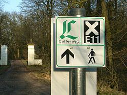
In the years after the fall of the Iron Curtain and German reunification, the Harz Club put much effort into restoring the network of rambling trails in the Eastern part of the Harz Mountains. This resulted inter alia in a completely new extension of E11 through the federal state of Saxony-Anhalt. It passes Ilsenburg and Ballenstedt, finally breaks through the crest of the Harz Mountains (which are hills rather than mountains here), and reaches the town of Lutherstadt Eisleben, the birthplace of Martin Luther, the church reformer, and bears his name in its official name.
A further extension, long planned, but realized only in 2007, leads E11 through mining and large-scale agricultural country to the Natural Park of the Lower Saale (Naturpark Unteres Saaletal). E11 continues to the city of Halle. This remarkable town survived the Second World War almost undamaged and retains a great number of buildings reflecting Jugendstil, Bauhaus and other architectural styles. The path west of Halle is waymarked in the same manner as the previous parts, i.e. a white cross (X), possibly on a black square.
After Halle, E11 climbs the lonely hill of Petersberg and continues through flat, open land. The scenery reflects both the large scale of agrarian enterprises in the new federal states as well as the influence of Brandenburg-Prussian nobility in the 18th and 19th centuries. E11 reaches the city of Dessau, the cradle of Bauhaus architecture, then plunges into the interesting Biosphere Reserve of the Middle Elbe. It passes Coswig and enters the forest around Senst. Shortly after this village, E11 reaches the border with the federal state of Brandenburg. After Halle, E11 is waymarked according to the traditional system in former communist Europe: three horizontal stripes, white, blue and white, which may also be interpreted as a blue stripe on a white square.
Brandenburg and Berlin (348 km)
E11 enters Brandenburg near Gross-Marzehns and crosses broad treeless agrarian land towards the picturesque town of Belzig. The trail continues through vast hunting forests, which were the property of the Brandenburg-Prussian nobility in the 19th century and served as a green belt around Berlin and Potsdam in the 20th century. About 20 kilometers before Potsdam, E11 reaches the first of a score of lakes bordered by many former East German holiday resorts, some of which are still in use. In front of Potsdam's monumental central railway station (Potsdam Hauptbahnhof) E11 meets E10, running North-South and also marked white-blue-white.
Crossing Potsdam near the Central Railway Station takes little time as E11 avoids the interesting historical town center and the luxurious palaces of the former dukes of Brandenburg, who became kings of Prussia and emperors of Germany. E11 sneaks through one of the hottest spots on the former border of West Berlin, Klein Glienicke. This little settlement, enclosed by water and divided by an indented border, was packed full of spies by both superpowers during the Cold War. The Glienicke Bridge witnessed the opening and subsequent fall of the Iron Curtain in 1989.
The routing through former West Berlin surprises with a vast area of forest before the Olympic Stadium in Charlottenburg is reached. This part of Berlin is rich in historical castles, including the winter residence of the Prussian kings, who also founded a few museums here. Most of the famous museums of Berlin are, however, found in Mitte (the historical center of Berlin and also the center of the former East Berlin. E11 does not pass here, but follows an old trail in West Berlin along the River Spree and the Landwehr Canal, thus missing the most interesting parts of East Berlin and present-day Berlin.
The borough of Köpenick is where E11 enters former East Berlin. E11 lingers leisurely between the River Spree and a few recreational parks and then crosses the river by ferry into a vast area of town houses and bungalows to Friedrichshagen. Here, E11 leaves the urban area behind to venture to the North into one of the most beautiful parts of the trail, the valley of the little river Erpe or Neuenhagener Mühlenfließ. Turning East, the trail now passes through Neuenhagen and the Märkische Schweiz Nature Park to Gusow near the town of Seelow. From here, the rambler may choose a more western trail over the hills of Lebus to Jacobsdorf or, more to the East, the trail that, after the village of Reitwein, follows the River Oder to the South. Both variants meet each other in Frankfurt (Oder), where the German part of E11 ends on the bridge over the Oder to Poland.
In Brandenburg and Berlin, E11 is marked in various ways. This part of E11 is described in the German language, A list of 150 addresses which offer lodgings for the night en route, also in German, is found in specialized bookshops in Germany. Some useful information is found at Fernwege.de, but as such not enough to follow the trail. It is strongly advised to carry a city plan of Berlin when walking from Potsdam to Neuenhagen. Locally bought topographical maps will do for the rest of the trail in Brandenburg.
E11 in Poland (1177 km)
In Poland, E11 continues east, then northeast, to pass the cities of Międzychód, Poznań, Gniezno, Toruń, Brodnica, Iława, Olsztyn and Gołdap to the township of Ogrodniki, Sejny County on the Lithuanian border. As 30% of Poland is covered with forest, it is not surprising that most of E11 crosses through vast areas with trees (mostly planted and exploited commercially), and various wild areas, such as lakes and dunes. Near Poznań, however, the rambler walks for days through agrarian and semi-industrial land, made pleasant by some ancient towns and buildings. As Poland is rather thinly populated, ramblers without tents must be prepared for daily distances between 25 and 35 kilometers.
No Polish regional trail is, as a whole, part of E11. The trail rather jumps from one existing trail to another, generally after following such a trail for only a short distance. Moreover, E11 is not itself waymarked on the route, with a few exceptions which may amount to one sign every 100 km. The regional trails are marked, however, although not always well enough to enable the rambler to follow E11 without a map.
Some topographical maps show sections of E11, but others may only show the trails that form the basis of it. So one must fall back on documents describing which sections of which trails make up E11. Unfortunately, these are hardly accessible or are incomplete:
Oder bridge - Międzyrzecz (141 km)
Once the bridge across the River Oder (and the now open border between Germany and Poland) has been passed, E11 (here unmarked) goes straight through the town center of Słubice, until 1945 a suburban part of Frankfurt (Oder) under the name of Dammvorstadt, but a separate township in a different country since then. Two kilometers out of town, E11 curbs left toward the little village of Drzecin, where the first white-yellow-white markings are found. These lead in a few days to Lubniewice, where the markings change to white-blue-white. The blue trail passes Kursko and leads to Kęszyca Leśna, a former army base of the Soviet Red Army that now tries to build up a second life as an industrial and tourist settlement. The former staff quarters now function as a hotel, where the hiker may rest as a Soviet general. A little further lies Kęszyca, where a German system of underground corridors and strongholds can be visited. This dates back to 1928, when democratic Germany (the Weimar Republic) felt the need to defend itself against a possible attack from the East with a so-called Ostwall. In 1938 already, this defense system started to deteriorate as dictator Adolf Hitler was more interested in attacking himself to the East and saw no need for a defense system that, from his point of view, lay somewhere inland in his dreamed Great Germany. The spot offers now the unique possibility of following E11 underground.
The blue trail carries E11 on to the township of Gościkowo, where the Paradyż Abbey sometimes hosts tired ramblers overnight, provided they accept the sober rules of monk life. After Gościkowo, white-green-white marks lead through some 30 km of forest to Bobowicko. Actually, between Kursko and Bobowicko, E11 follows a large bow around the city of Międzyrzecz. The city has bus and train connections with various townships on E11 and may be used as a pleasant station for two or three days of walking without much luggage. Bobowicko is at walking distance (2 km) from the train and bus stations of Międzyrzecz. Due to its train connections to Poznań and Germany, Międzyrzecz is also a good place to end or start a tour of one or more weeks along E11. The city has an interesting regional museum and a lively score of restaurants and bars.
Międzyrzecz - Poznań-Kiekrz (133 km)
From Bobowicko, the green trail continues till after Stołuń, where E11 begins to follow white-blue-white to Villa Toscana, a lonely hotel between the villages of Nowe Gorzycko and Stare Gorzycko. The blue trail and E11 continue to the twin cities of Międzychód and Bielsko, which offer many opportunities for shopping (fashion, antiquities, arts) and staying overnight. E11 now enters the area that, for a long time, was No Man's Land and War Front Zone between Prussia (later the German Empire) and Poland. Many monuments remind of this tragedy, but unfortunately the explanatory texts are in Polish only. In Bukowar the markings change to white-red-white and in Obrzycko to white-green-white. Słopanowo marks the end of the forests; E11 now enters the agrarian open space of the province of Greater Poland around the city of Poznań. There are no marks after Szamotuły. The village of Kiekrz is where E11 reaches Poznań.
E11 through Poznań (33 km)
From behind the railway station of Kiekrz, a white-green-white marked trail leads through a vast city park to Golęcin, from where a few black or blue marks guide the rambler to the tramway stop of Sołacz and Nad Wierzbakiem. After this point, E11 is not defined, but the obvious choice of a rambler interested in one of the oldest, biggest and most beautiful town centers along E11 is to turn right (South) toward Rynek Jezycki. Here begins The Royal-Imperial Route in Poznań which, in a more or less straight West-East line, passes all touristical highlights of Poznań. This tourist trail ends at the medieval little Church of St. John of Jerusalem Outside the Walls near Lake Malta. The quiet Northern shore of this Jezioro Maltańskie offers interesting views of the many sports accommodations on and around the lake and guides the E11 rambler to the zoo and the start of the well-marked but curving Cistercian bicycle track (black monks on a white field or simple black stripes). Lodgings and buses back to town are found just across the border of the city in Gruszczyn. The last residential area of Poznań is Zieliniec.
Poznań-Zieliniec - Gniezno (55 km)
Crossing the main road in Gruszczyn, E11 goes straight, in line with Map N-33-131/132, to Pobiedziska. E11 passes over a tar road through a nondescript area of small businesses and workshops related to agriculture. Later, it ventures into forest until finally all black or green markings leave the path and die somewhere in the forest and the dunes. One should rather follow the nearby tar road to the North, to the township of Pobiedziska, where E11 is found back. Away from the track, to the West of the town, open-air museum Skansen welcomes visitors with miniature copies of buildings from a wide area.
In Pobiedziska itself, the Ulica Gnieźnieńska at the left of the church on the central square of Pobiedziska carries E11 out of town. Through open, mostly agrarian land, the scattered houses of Lednogóra are reached, where white-red-white markings join the trail. This is from now on the colour of E11 over more than 100 kilometres. Along a swampy lake and a crossing in the main road #5 (at the crossing a road sign says that it is now 22.2 kilometres to Gniezno), E11 reaches the railway station of Fałkowo, which is crossed at full length. Here E11 has been forced to make place for a motorway. After Leśniewo scarce white-red-white signs can be found again, leading the aware and persistent rambler to Gniezno.
Gniezno was the first capital of Poland, way back in the Middle Ages, but it is now dreaming away as a provincial town. Old and beautiful houses and other buildings around the central square testify of an interesting past, whilst decaying factories refer to the recent communist past. The university offers the most lively corner of the town. The white-red-white marks of E11 lead along the most interesting churches, museums and other sites, and finally to the railway station.
Gniezno - Toruń (136 km)
A few signs in front of the railway station of Gniezno indicate distances along the red-marked trail that is E11. The 40 km to Mogilno are correct, but the distance to Kruszwica is severely exaggerated. The trail follows the road parallel to the tracks to the Northeast and turns then right into a tunnel under the railway. After another right turn, it passes through a modern industrial area, older residential quarters and a surprisingly wild patch of forest. The red markings lead through open agrarian land to the long-stretched industrial village of Trzemeszno. The trail passes in front of the railway station, crosses the tracks a little further, and reaches Mogilno via the village of Wydartowo. The white-red-white stripes die out in Mogilno. E11, now invisible, turns right in the little park around the lake, not far from the railway station, and immediately right again, to follow the waterside toward the medieval Benedictine monastery. E11 turns left (East) to the lonely motel of Goryszewo Kwieciszewo, where the first white-red-white stripes since Mogilno are found. The trail passes through Jeziorki and follows a sandy dirt road to Strzelno.
After Strzelno, a Polish Way of St. James follows more or less the same route as the E11, so that the yellow and blue shells yield an alternative marking to reach Polanowice. In this soviet-industrial village two rusty signs with white-red-white stripes are found, which still clearly indicate E11 (200 km after the previous E11 sign!). A rustic tree lane brings the rambler to Kruszwica, a provincial town with some interesting churches, but no clue where E11 and the Way of St. James continue. Gorges invites to look for a trail marked blue, but the only blue trail to be found makes a short circuit through a suburb of Kruszwica. A better bet is to follow the busy main road to the North, which is marked with the shells of St.James. After 7 km, near Łojewo, one may take a quiet asphalt road, soon unpaved and marked blue. The blue signs lead finally through long-stretched suburbs to the city center of Inowrocław.
Near the railway station of Inowrocław a torn map of the city is found, which indicates where the red-marked E11 leaves the town. The insufficiently marked trail crosses the fields of Kolonie Szadłowice and enters the forests of Błoto Ostrowskie. Finally, one comes to the village of Wierzbiczany, from where both the red markings and the blue shells of St.James lead through agrarian land to the center of Gniewkowo. They follow a right curve and leave the town on the asphalt road towards Cierpice to the North. The trails now enter a large forest, leave the tar road after some kilometers and make a wide curve of 16 km to the village of Cierpice, the first of a chain of suburbs of Toruń. In spite of Gorges, E11 no longer passes through Suchatówka. The blue trail ends at the PTTK office in the town centre of Toruń.
Toruń - Brodnica (87 km)
From the PTTK office in Toruń, E11 is identical to a trail marked white-yellow-white, which leads all the way to Samborowo, 200 km to the Northeast. E11 and St. James Way avoid the historical town center of Toruń and pass between the old city walls and the river Wisla, but it is far more interesting to cross the city center from the PTTK office by Różana, Szeroka and Wielkie Garbary to the train station of Toruń-Miasto. Out of town, the trails follow a main road till Fort Sobieskiego. They turn right into the forest near the river Wisla, enter suburbs and later pass through forest for a couple of hours. After crossing the busy motorway A10 near Brzozówka, E11 turns left into an overgrown footpath between fields and later reaches Mierzynek over a sandy road. From Lelitowo to Ciechocin and again to Golub-Dobrzyń, E11 continues through a variety of natural and commercial forests along the river Drwęcą.
E11 leaves the twin cities without markings near the Post Office and the cemetery on National Road # 534. The trail follows roughly the river Drwęcą to the North-East, and the first yellow signs are found in the forest. The trail then alternates between river side woods and agrarian settlements. Some of these remind of the composer Chopin who spent holidays in this area and now has a museum in Szafarnia. In Radziki Duże E11 turns left over a paved road with heavy lorries carrying loads from a sand quarry. It takes about an hour to reach a bridge over the Drwęcą and escape from the road into the forest on the other side of the river. This sandy forest road continues till Mszano, but in a new suburb under Szabda it turns into a paved road and subsequently a main road leading to Brodnica.
Brodnica - Olsztyn (237 km)
E11 and St. James Way leave Brodnica well-marked, but avoiding the nice but neglected old city centre. The trails follow Motorway A15 and an abandoned railway track into forest, and meets the A15 again near the bridges of Tama Brodzka. Right after the bridge, the trails turn left into a small paved forest lane leading to Bachotek, where they split. E11 makes a few curves near Jezioro Zbiczno and meets a trail marked green. Here the yellow signs are missing, but the green signs must be followed to the North until a paved road. The asphalt is followed to the East over about one kilometer between two lakes. Here the green trail and the yellow-marked E11 split up. E11 passes twice near the tourist resort of Ciche and turns West to Gorále, then North to the railway station of Ostrowite, and finally East.
The yellow-marked E11 continues to the East until Radomno, where it unites with St. James Way and turns North to Iława. They pass the modern center of the city, which was heavily destroyed in the Second World War, and continue North by Szalkowo to Tynwald, then East to Samborowo. From here a blue-marked section of E11 leads to Waplewo, passing the forested tourist resort of Wysoka Wieś and the historical site of the Battle of Grunwald (1410).
Between Waplewo and Olsztyn, E11 makes a long half-circle through two natural reserves. The first protects the springs of the Łyna River, which E11 then begins to follow all the way through Olsztyn to Lidzbark Warmiński. A little further down is the conservation area of Las Warminski, which is especially interesting. It shows the results of decades of minimal management, with nature returning to its course before mankind settled in the area. Rare species may be encountered here, including the Eurasian lynx, according to a local signpost.
Olsztyn - Gołdap (243 km)
The historical city center of Olsztyn with its variety of museums, restaurants, theatres and hotspots for night life is without doubt a place where even the most fanatic E11 rambler wants to spend a day of rest. It is the gateway to the former coreland of the Teutonic Order, now characterized by little towns with remnants of huge castles. Of these, E11 passes Dobre Miasto, Lidzbark Warmiński, Bisztynek, Reszel and Kętrzyn. Other buildings remind of the more recent, but also Roman Catholic past, for example the Palace of the bishops of Warmia at Smolajny, the monastery of Stoczek and the shrine of Święta Lipka.
Gołdap - Lithuanian border (144 km)
In Gołdap, E11 offers a choice between a trail marked white-green-white that comes very close to the Russian border, or a white-red-white trail along the main road to the East. Both trails meet again after 31 km in Stanczyki. The green trail passes through uninhabited woodland and should not be recommended to ramblers with a weak sense of orientation, or those who fear Russian red tape when crossing the border unintentionally and without visa. That one reaches the Russian border before Lithuania, may be surprising to those who are not aware that Russia has an exclave around Kaliningrad, formerly German Königsberg.
E11 ends at the Polish-Lithuanian border post at 3 km from Ogrodniki. Here is no possibility to spend the night, the nearest lodgings are found in Sejny, 11 km along the main road, or 13 km by following the black trail back and then the red trail to the right. Those who venture into Lithuania may find a guesthouse in Lazdijai. Both towns have no train connections; to take a train home or to an airport, one may follow the red trail from Sejny over 25 km to the railway station of Trakiszki near Puńsk. There are also railway stations in the Polish city of Suwałki and the Lithuanian city of Šeštokai. Be prepared to wait long; there seems to be only one train in either direction from these places except Suwałki that offers three trains daily to Białystok.