
Year built 1961 | ITV region STV North | |
 | ||
Mast height 322.0 metres (1,056 ft) Similar Caldbeck transmitting station, Arfon transmitting station, Beacon Hill transmitting station, Mendip transmitting station, Black Hill transmitting station | ||
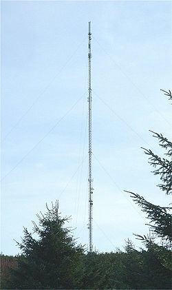
The Durris transmitting station is a broadcasting and telecommunications facility, situated close to the town of Stonehaven, within Durris Forest, within the area also known historically as Kincardineshire (grid reference NO763899). It is owned and operated by Arqiva.
It has a 306.6 metres (1,006 ft) high guyed steel lattice mast. The analogue television transmission antennas surmounting the structure are contained within a GRP cylinder, and bring the overall height of the structure to 322.0 metres (1,056 ft), making it the tallest structure in Scotland. It was constructed in 1961 and coverage includes north east Scotland, from St. Andrews in the south to Fraserburgh in the north, including the city of Aberdeen. It also covers much of the North Sea coast between Dunbar and Berwick, although this coverage is not deliberate.
It is also a feature in Durris Primary's newest logo created in 2000 (the logo shows the mast on the hill with the sun and three trees).
It can be seen from the summit of Mither Tap, near Insch, Aberdeenshire and can also be spotted at night on the road down from the Lecht Ski Centre.
Analogue television
Analogue television was switched off during September 2010; BBC Two Scotland was closed on 1 September and the remaining four on 15 September.