
Province Alberta | ||
 | ||
Duhamel is a hamlet in the central Alberta, Canada within Camrose County. It is located on Highway 21, approximately 100 kilometres (62 mi) southeast of Edmonton and 20 kilometres (12 mi) southwest of Camrose, Duhamel's closest major trading centre.
Contents
Map of Duhamel, AB, Canada
History
An early trading post was situated 2-3 miles northwest of the hamlet's current site, directly on a well-used ford of the Battle River. The trading post was a key point for exchange between the First Nations people, fur traders, and the Hudson's Bay Company.
The settlement that grew around the post took the names Battle River Crossing and Salois's settlement or Abram's settlement, after Abram Salois, a prominent settler and freighter. It was also known as Laboucane, after the Laboucane brothers and their families, who were among the first local residents.
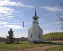
A church was built in 1883 for the service of Father Bellevaire, and was visited by Bishop Grandin, who named the settlement after Joseph-Thomas Duhamel.
Around 1886, the post was moved to the site where Highway 21 now crosses the river (52°57′N 112°58′W).
In 1910, Duhamel moved to its present location on the newly constructed Grand Trunk Pacific rail line from Tofield to Calgary. The Duhamel/Battle River rail bridge was one of the largest wooden rail bridges ever constructed, at 3,972 feet (1210 m) in length and 120 feet (32 m) in height.
Geography
Nearby communities include:
Demographics
As a designated place in the 2016 Census of Population conducted by Statistics Canada, Duhamel recorded a population of 47 living in 18 of its 18 total private dwellings, a change of 7001567000000000000♠56.7% from its 2011 population of 30. With a land area of 1.25 km2 (0.48 sq mi), it had a population density of 37.6/km2 (97.4/sq mi) in 2016.
As a designated place in the 2011 Census, Duhamel had a population of 30 living in 12 of its 15 total dwellings, a -14.3% change from its 2006 population of 35. With a land area of 1.29 km2 (0.50 sq mi), it had a population density of 23/km2 (60/sq mi) in 2011.
The population of Duhamel according to Camrose County's 2008 municipal census is 31.
Crop circles
Crop circles appeared in a farmer's field in Duhamel in 1967. At the time, crop circles were virtually unknown. The discovery of the circles was preceded by reports of UFO sightings around the town.
A farmer by the name of Schielke discovered the strange occurrence on Saturday, August 5, 1967, after a night of heavy rains. This was the first time he had been to his fields in weeks, so the circles could have appeared at any time during that period. The circles were composed of four circular marks approximately 30 feet (9.1 m) in diameter. Schielke always stressed that the marks could not have been made by his equipment, and that he did not believe in UFOs.
The marks varied from five to seven inches wide, and the smallest circular mark was 31 ft., 9 in. in diameter. Three of the rings were essentially circular, with the largest mark being slightly elliptical, varying from 34 ft., 5 in. to 36 ft., 3 in. There were no exhaust blasts, scorch marks or disturbances of the soil, and vegetation within the circles had apparently been removed by the object that made the marks. The official investigation report implies that the marks were most likely left by a 135-ton aircraft or spacecraft.
This case is described as "unsolved" by Canada's Department of National Defence.