
GNIS ID 407441 | Length 46 km Country United States of America | |
 | ||
Sources West Branch DuPage River, East Branch DuPage River Cities | ||
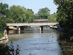
Dupage angler on the dupage river naperville il
The DuPage River is a 28.3-mile-long (45.5 km) tributary of the Des Plaines River in the U.S. state of Illinois.
Contents
- Dupage angler on the dupage river naperville il
- Map of DuPage River Illinois USA
- Detecting illinois in will county at an old site along dupage river
- Course
- Flooding
- History
- References
Map of DuPage River, Illinois, USA
Detecting illinois in will county at an old site along dupage river
Course
The river begins as two individual streams. The West Branch of the DuPage River, 35.0 miles (56.3 km) long, starts in Schaumburg at Campanelli Park in Cook County and continues southward through the entire county of DuPage, including the towns of Bartlett, Wheaton, Warrenville, Winfield and Naperville (including through its riverwalk). The East Branch of the DuPage River, 25.0 miles (40.2 km) long, begins in Bloomingdale and flows southward through Glendale Heights, Glen Ellyn, Lisle, Woodridge, parts of Naperville and parts of Bolingbrook. The two branches meet at a spot between Naperville and Bolingbrook. The combined DuPage River continues southward from that point, through Plainfield & Shorewood and then west of Joliet, before finally meeting the Des Plaines River.
Flooding
Like many local bodies of water, both branches of the DuPage River seriously overflowed after the "Flood of 1996", when approximately 17 inches (430 mm) of rain fell on the area within a 24-hour period, on July 18–19 of that year. Other flooding was also very common, along Washington Street in Naperville and Illinois Route 53 in Glen Ellyn, because those roads are close to their respective branches of the river. The City of Naperville has torn down many of the affected homes and businesses, in the former case, and DuPage County, with U.S. Department of Transportation funding, tore down many of the affected homes in the latter case. A new dam that was built in 2009 has been a tremendous help in managing the river's level.
History
The first written history to address the name, the 1882 History of DuPage County, Illinois, relates that:
The Du Page River had, from time immemorial, been a stream well known. It took its name from a French trader who settled on this stream below the fork previous to 1800. Hon. H. W. Blodgett, of Waukegan, informs the writer that J. B. Beaubien had often spoken to him of the old Frenchman, Du Page, whose station was on the bank of the river, down toward its mouth, and stated that the river took its name from him. The county name must have the same origin. Col Gurden S. Hubbard, who came into the country in 1818, informs the writer that the name DuPage, as applied to the river then, was universally known, but the trader for whom it was named lived there before his time. Mr. Beaubien says it is pronounced Du Pazhe (a having the sound of ah, and that the P should be a capital). This was in reply to Mr. Blodgett’s inquiry of him concerning the matter.