
Width 1 km (0.6 mi) Highest elevation 200 m (700 ft) Elevation 200 m | Length 2.5 km (1.55 mi) Coastline 6 km (3.7 mi) Highest point Drynjahatten Area 170 ha | |
 | ||
Dryna hot16challenge grc zbynio adhd dejw nelson
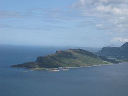
Dryna is an island in Midsund Municipality in Møre og Romsdal county, Norway. It is the westernmost of the main islands in the municipality. The 1.7-square-kilometre (0.66 sq mi) island sits between the Harøyfjorden and the Midfjorden, at the entrance to the great Romsdalsfjorden. Until 1965, Dryna was part of Haram Municipality.
Contents
Map of Dryna, 6475 Midsund, Norway
Dryna has a road connection to the neighboring island of Midøya to the east. There are ferry connections from the western end of the island to Brattvåg (in Haram Municipality) and Myklebost (in Sandøy Municipality).
The name
The Old Norse form of the name was Dryn. The name is probably derived from the word drynr which means "rumble" or "roar" (referring to the swell of the waves against the island).
References
Dryna Wikipedia(Text) CC BY-SA