
OS grid reference SP4600 Post town Oxford Dialling code 01865 | Sovereign state United Kingdom Postcode district OX13 Civil parish St. Helen Without | |
 | ||
Dry Sandford is a village in the Vale of White Horse district of England, about 3 miles (5 km) north-west of Abingdon. It is one of two villages in the civil parish of St Helen Without. It was part of Berkshire until the 1974 boundary changes transferred the Vale of White Horse to Oxfordshire.
Contents
Map of Dry Sandford, Abingdon, UK
Manor
The Domesday Book of 1086 records the place as Sanford. The "sandy ford" must have been across the stream now known as Sandford Brook, a tributary of the River Ock, once known as the Lucringe. The village became known as Dry Sandford by the 18th century.
Dry Sandford was a manor in the parish of St Helen's, Abingdon, and was held by Abingdon Abbey until the Dissolution in 1538.
Parish church
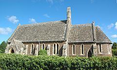
The Church of England parish church of Saint Helen is a 13th-century-style Gothic Revival building designed by J.B. Clacy of Reading and built in 1855. St. Helen's has lancet windows, a nave, chancel, rib-vaulted apse and a bellcote on the gable above the chancel arch. St. Helen's was made a separate ecclesiastical parish in 1867, but was united in a single benefice with St. Peter's, Wootton in 2000.
Amenities
Dry Sandford Pit is a nature reserve just south of the village managed by the Berks, Bucks and Oxon Wildlife Trust. The site is of geological importance for its exposure of Corallian beds, and is designated a Site of Special Scientific Interest.