
- right Red Creek - elevation 1,700 ft (518 m) Discharge 21.41 m³/s Cities Hendricks | - elevation 3,740 ft (1,140 m) Length 63 km Country United States of America | |
 | ||
- left Glady Fork, Laurel Fork, Otter Creek - location Col between Harper and Yokum knobs, Randolph County - location Hendricks, Tucker County Source Randolph County, West Virginia Mouths Hendricks, Black Fork, Blackwater River | ||
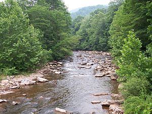
The Dry Fork is a 39.1-mile-long (62.9 km) tributary of the Black Fork of the Cheat River in the Allegheny Mountains of eastern West Virginia, USA. Via the Black Fork, the Cheat, and the Monongahela and Ohio rivers, it is part of the watershed of the Mississippi River. The Dry Fork flows for much of its length in the Monongahela National Forest and drains mostly rural and forested areas. It was traditionally considered one of the five Forks of Cheat.
Contents
Map of Dry Fork, West Virginia, USA
NameEdit
According to the Geographic Names Information System, Dry Fork has also been known historically as Dry Run. The stream's name derives from the occurrence of underground passages through which portions of the stream flow, leaving a dry streambed on the surface at times during the year. (See Sinks of Gandy)
CourseEdit
The Dry Fork rises between Rich Mountain and Little Middle Mountain in eastern Randolph County and initially flows north-northeastwardly, past the towns of Whitmer, Job, and Harman. After it enters Tucker County (at Dryfork) it turns to the northwest and flows to the town of Hendricks, where it meets the Blackwater River to form the Black Fork.
TributariesEdit
Gandy Creek — which passes through the well-known cave known as the "Sinks of Gandy" — joins Dry Fork at the town of Gandy. In the lower part of its course the Dry Fork collects the Laurel Fork, which joins it in Randolph County, and the Glady Fork, which joins it in Tucker County. Both of these are also considered principal tributaries of the Cheat River. Red Creek — which enters Dry Fork at the town of Dryfork — drains much of the Dolly Sods Wilderness area.