
Irish grid reference H1969 Postcode district BT Province Ulster Dialling code 28 | Sovereign state United Kingdom | |
 | ||
UK parliament constituency | ||
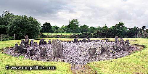
Drumskinny stone circle
Drumskinny (from Irish Droim Scine, meaning 'ridge of the knife/edge') is the site of a stone circle in the townland of Drumskinny, County Fermanagh, Northern Ireland. With the inclusion of an adjacent cairn and alignment, the stone circle is a State Care Historic Monument in Fermanagh and Omagh district, at grid ref: H 2009 7072. The site was excavated in 1962 and is believed to have built around 2000 BC.
Contents
- Drumskinny stone circle
- Map of Drumskinny Enniskillen UK
- Caldragh graveyard drumskinny stone circle and loughcrew cairns
- References
Map of Drumskinny, Enniskillen, UK
There are also two other townlands in Northern Ireland called Drumskinny: in the civil parish of Clonfeacle in County Tyrone; and in the civil parish of Dromore also in County Tyrone.
Caldragh graveyard drumskinny stone circle and loughcrew cairns
References
Drumskinny Wikipedia(Text) CC BY-SA