
Airport type Public Elevation AMSL 682 ft / 208 m 15/33 7,000 Code TPL Phone +1 254-298-5770 | Serves Temple, Texas Website www.TempleTexas.us/... 7,000 2,134 Elevation 208 m Owner City Of Temple | |
 | ||
Address 7720-F Airport Rd, Temple, TX 76501, USA Similar Temple Station, Railroad & Heritage Museum, Greyhound Lines, Waco Regional Airport, City Of Temple | ||
Draughon–Miller Central Texas Regional Airport (IATA: TPL, ICAO: KTPL, FAA LID: TPL) is a city owned, public use airport located five nautical miles (6 mi, 9 km) northwest of the central business district of Temple, a city in Bell County, Texas, United States. It is included in the National Plan of Integrated Airport Systems for 2011–2015, which categorized it as a general aviation facility.
Contents
History
In July 1942, the United States Army Air Forces acquired pasture land and began construction of Temple Army Airfield. including three concrete runways, several taxiways, a large parking apron and a control tower, along with housing and other buildings for support services. Buildings were utilitarian and quickly assembled. Most base buildings, not meant for long-term use, were constructed of temporary or semi-permanent materials. Although some hangars had steel frames, and the occasional brick or tile brick building could be seen, most support buildings sat on concrete foundations but were of frame construction clad in little more than plywood and tar paper.
Temple AAF was a sub-base of Waco Army Airfield and was used as a basic flying school by the Army Air Forces Flying Training Command, Gulf Training Center (later Central Flying Training Command). Cadets received basic flying indoctrination and training, primarily in North American BT-9s and Stearman PT-17s. By late 1944, its primary activity was multi-engine transition training and combat crew assembling on North American B-25 Mitchell medium bombers. Flight training continued until the base was closed on 31 October 1945.
With the end of the war the airfield was determined to be excess by the military and turned over to the City of Temple, which closed "Temple Municipal Airport," [which had been built about 2 miles northwest of the central business district in 1937 by Works Progress Administration] and renamed Temple Army Airfield "Draughon–Miller" in honor of two Temple fliers who had died in World War II. The city used the former site of Temple Municipal Airport first as a landfill, and later for a planned industrial area.
Facilities and aircraft
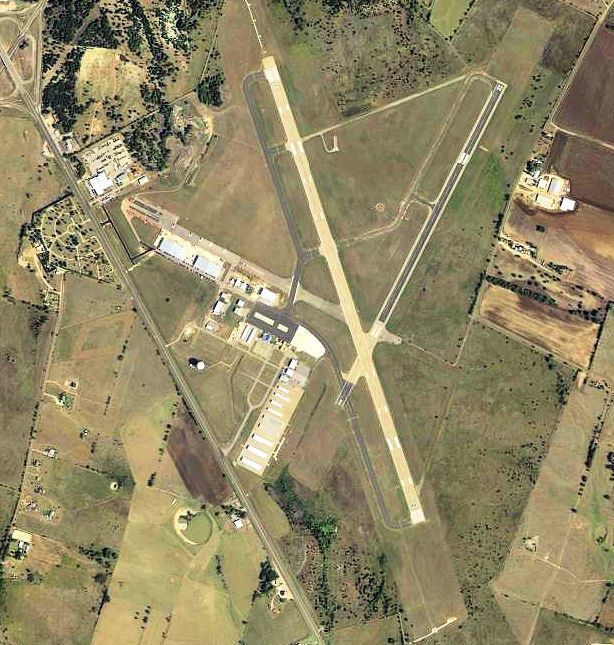
Draughon–Miller Central Texas Regional Airport covers an area of 922 acres (373 ha) at an elevation of 682 feet (208 m) above mean sea level. It has two asphalt paved runways: 15/33 is 7,000 by 150 feet (2,134 x 46 m) and 2/20 is 4,740 by 100 feet (1,445 x 30 m).
For the 12-month period ending May 31, 2010, the airport had 48,276 aircraft operations, an average of 132 per day: 85% general aviation and 15% military. At that time there were 227 aircraft based at this airport: 65% military, 31% single-engine, 2% multi-engine, 2% jet, and <1% helicopter.