
Last eruption 5651 BC Parent range Cariboo Mountains | Elevation 1,830 m Province British Columbia | |
 | ||
Similar Kostal Cone, Flourmill Volcanoes, Wells Gray‑Clearwater volcanic fi, Cocoa Crater, White Horse Bluff | ||
Asmr dragon cone incense burner
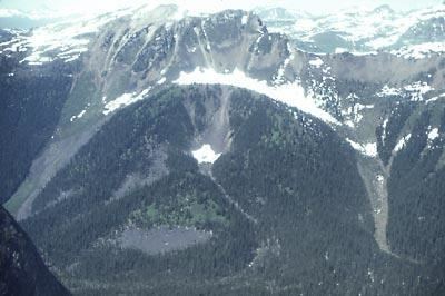
Dragon Cone is a monogenetic cinder cone located in Wells Gray Provincial Park in east-central British Columbia. It is the source of a 15 km (9 mi) long lava flow, called Dragon's Tongue. This lava covered the floor of narrow Falls Creek Valley and terminated at the Clearwater River, damming it to a height of 3 m (10 ft) and raising the level of existing Clearwater Lake upstream. Geologists have recovered some peat buried by the lava and radiocarbon dating produced an age of 7560 years plus or minus 100 years. Flows from nearby Flourmill Cone, Kostal Cone and Spanish Lake Cones rest on glaciated bedrock without an intervening paleosol, suggesting an early Holocene age.
Contents
- Asmr dragon cone incense burner
- Map of Dragon Cone Thompson Nicola A BC Canada
- Dragon cone incense burner
- References
Map of Dragon Cone, Thompson-Nicola A, BC, Canada
Visits to Dragon Cone are very rare due to difficult access. The nearest trail is the overgrown Kostal Lake Trail, over 5 km (3.1 mi) to the south. Falls Creek is impassable for boats. The cone is best viewed from the air, but float plane landings on nearby Ray Lake are not permitted.