
Population 3,940 (2011 census) LGA(s) Waverley Council Dover Heights Tasman Sea Federal division Division of Wentworth | Postcode(s) 2030 State electorate(s) Vaucluse Postal code 2030 | |
 | ||
Location 9 km (6 mi) from Sydney CBD | ||
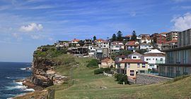
Dover Heights is a coastal, eastern suburb of Sydney, in the state of New South Wales, Australia. Dover Heights is 9 kilometres east of the Sydney central business district, in the local government area of Waverley Council. Its postcode is 2030.
Contents
- Map of Dover Heights NSW 2030 Australia
- Location
- History
- Population
- Sport and recreation
- Radar station
- References
Map of Dover Heights NSW 2030, Australia
Location
Dover Heights borders Vaucluse to its north, North Bondi to its south and Rose Bay to its west and has the Pacific Ocean to its east.
Dover Heights is a mainly residential suburb. Many of the suburb's properties have views of Sydney Harbour and the Sydney Harbour Bridge. Its Dudley Page Reserve is a popular site for tourist buses. Some properties have both harbour and ocean views. The Holman House, Dover Heights, was presented the Wilkinson Award by the Royal Australian Institute of Architects in 2005.
The suburb is considered to be the most affluent within the Waverly Local Government Area, and amongst the most affluent suburbs in Sydney. This is reflected in property prices - like nearby suburbs Vaucluse and Bellevue Hill, median house prices are above A$2 million.
History
Dover Heights is believed to have been named for its cliffs along the Pacific Ocean which resembled those found at Dover, in Kent, England. The first mention of Dover Heights appeared in municipal records in 1886. The area was first used for market gardens.
In 1830 land in the area was owned by Daniel Cooper (1785–1853), a partner in the firm Cooper and Levey, who owned the Waterloo Stores. The retailing emporium was located on the corner of George Street and Market Street in the city, on the site that was later occupied by Gowings Brothers retailers until 2006. The Dover Heights area was subdivided in 1913.
Population
At the 2011 census, there were 3,940 residents in Dover Heights. 53.7% of people were born in Australia with the most common other countries of birth being South Africa 14.1%, England 3.6% and Israel 2.3%. Judaism (53.3%) was the most common response for religion in Dover Heights. The median weekly household income was $2,508 and 34.4% of households had a weekly income of more than $3,000. Housing costs were high in Dover Heights with the median monthly mortgage payment being $4,275.
Sport and recreation
Since 1908, Dover Heights has been represented in one of Australia's most popular sporting competitions, the National Rugby League, by the Sydney Roosters, also known as the Eastern Suburbs District Rugby League Football Club.
Radar station
During the Second World War, Rodney Reserve, at the Dover Heights clifftop, was used by the Royal Australian Air Force for coastal defence radar. The CSIRO further used the site for pioneering experimentation in radio astronomy related to galactic radio emissions, with a team including John Gatenby Bolton first observing solar emissions in 1945. [1] The site primarily made use of Yagi antennas. [2] The first radio source they identified with
something that could be seen was in the constellation Taurus, and named Taurus A, which is in fact the Crab Nebula, a supernova remnant (the remains of an exploding star) first reported by Chinese astronomers in the year 1054.