
Width 3.7 km (2.3 mi) Population Uninhabited | Length 8.3 km (5.16 mi) Highest elevation 515 m (1,690 ft) Elevation 515 m | |
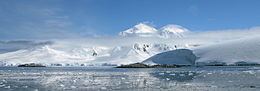 | ||
Doumer Island is an island 8.3 km (4.5 nmi) long and 3.7 km (2 nmi) wide, surmounted by a snow-covered pyramidal peak, 515 m (1,690 ft), lying between the south portions of Anvers Island and Wiencke Island in the Palmer Archipelago of Antarctica. It was first seen by the Belgian Antarctic Expedition, 1897–99, under Adrien de Gerlache. It was resighted and charted by the French Antarctic Expedition, 1903–05, under Jean-Baptiste Charcot, who named it for Paul Doumer, President of the French Chamber of Deputies and later President of France.
Map of Doumer Island, Antarctica
Chile's summer-only Yelcho research station, administered by the Chilean Antarctic Institute, stands on the southern shore of South Bay.
References
Doumer Island Wikipedia(Text) CC BY-SA