
Topo map USGS Dotsero Mountain type maar Elevation 1,874 m Population 705 (2010) | Age of rock Holocene Last eruption 2200 BCE ± 300 years Zip code 81637 Local time Friday 1:12 PM | |
 | ||
Location Dotsero, Colorado,
United States Weather 18°C, Wind W at 29 km/h, 18% Humidity Area 4.144 km² (3.626 km² Land / 52 ha Water) | ||
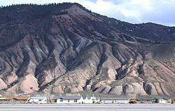
Dotsero is a 700-meter (2,300 ft) wide by 400-meter (1,300 ft) deep maar volcano located in Dotsero, Colorado near the junction of the Colorado River and the Eagle River. It is classified as a scoria cone with evaporitic rock, basaltic tephra, and oxidized sandstone. Erupting approximately 4200 years ago, it is the youngest volcano in Colorado.
Contents
- Map of Dotsero CO 81637 USA
- Dotsero stephen watts steppin outta th boat
- Eruption information
- References
Map of Dotsero, CO 81637, USA
Dotsero stephen watts steppin outta th boat
Eruption information
This Holocene volcano erupted in the year 2220 ± 300 years B.C. When Dotsero blew, it created small scoria cones that were constructed along a NNE-SSW line on either side of the maar. The eruption date is based upon radiocarbon dating of wood found underneath some of the scoria. It is one of the youngest eruptions in the continental U.S. and it produced an explosion crater, a lahar, and a 3-kilometer (1.9 mi) long lava flow.
Volcanoes that have erupted in the past 10,000 years are more likely to become active again.
Interstate 70 cuts across the lava flow.