
Lowest elevation 0 m (0 ft) Postal code 843 00 Area code 22850 | Highest elevation 385 m (1,263 ft) Time zone EET (UTC+2) Vehicle registration EM | |
 | ||
Donousa (Greek: Δονούσα, also Δενούσα - Denousa) is an island and a former community in the Cyclades, Greece. Since the 2011 local government reform it is part of the municipality Naxos and Lesser Cyclades, of which it is a municipal unit. Donousa is the easternmost island of the Lesser Cyclades.
Contents
Map of Donoussa, Donousa 843 00, Greece
Geography
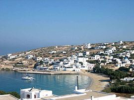
Donousa is located 16 km (10 mi) east of the island of Naxos and about 25 km (16 mi) north of Amorgos. Its area is 13.75 square kilometres (5.31 sq mi) and its highest point is 385 metres (1,263 ft). Its population is 167 inhabitants (2011 census), most of which live in the main settlement Donousa (also Stavros). Other villages include Mersini (on the southeastern coast), Kalotaritissa (near its northern coastline) and Charavgi (in the south).
References
Donousa Wikipedia(Text) CC BY-SA