
Country Thailand Time zone THA (UTC+7) Geocode 7206 Population 453,839 (2013) | Seat Don Chedi Postal code 72170 Area 252.1 km² Province Suphan Buri Province | |
 | ||
Don Chedi (Thai: ดอนเจดีย์; [dɔ̄ːn tɕēːdīː]) is a district (Amphoe) of Suphanburi Province, Thailand.
Contents
- Map of Don Chedi District Suphan Buri Thailand
- Geography
- History
- Central administration
- Local administration
- References
Map of Don Chedi District, Suphan Buri, Thailand
Geography
Neighboring districts are (from the north clockwise) Nong Ya Sai, Sam Chuk, Si Prachan, Mueang Suphanburi and U Thong, and in Kanchanaburi Province the district Lao Khwan.
History
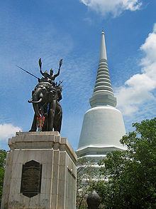
Prince Damrong Rajanubhab in 1913 discovered the remains of a large chedi within the district. He identified it as the one built by King Naresuan in 1593 after his win against the Burmese. The chedi was reconstructed in 1952. In 1959 a statue of the king on his war elephant cast by Silpa Bhirasri was added.
However, more recent research casts doubt on this identification. Although one of the chronicles explicitly places the battle at Suphanburi, the others don't give any clear location. The Dutch merchant Jeremias van Vliet, however, wrote in his Short History of the Kings of Siam in 1640 that the battle took place near Ayutthaya - which would make Chedi Phu Khao Thong the likely place of this battle.
The area of the district was originally part of Si Prachan district. It was established as a minor district (King Amphoe) on January 1, 1962, consisting of the two tambon Don Chedi and Nong Sarai. It was upgraded to a full district on July 27, 1965.
Central administration
The district Don Chedi is subdivided into 5 subdistrict (Tambon), which are further subdivided into 50 administrative villages (Muban).
Local administration
There are 2 subdistrict municipalities (Thesaban Tambon) in the district:
There are 5 subdistrict administrative organizations (SAO) in the district: