Puneet Varma (Editor)

Dolores Partido

Updated on
Edit
Like
Comment
Share on FacebookTweet on TwitterShare on LinkedInShare on Reddit
Country
  
Argentina

Founded by
  
Ramón Lara

Demonym(s)
  
dolorense

Established
  
17 August 1817

Seat
  
Dolores

Postal Code
  
B7100

Dolores Partido

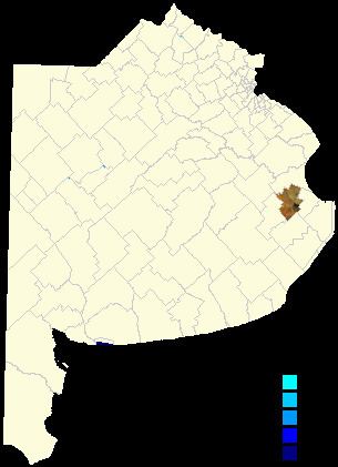
Dolores Partido is a partido situated in the eastern part of Buenos Aires Province in Argentina. It borders the partidos of Castelli, Tordillo, Maipú, General Guido and Pila.

Contents

Map of Dolores Partido, Buenos Aires Province, Argentina

The provincial subdivision has a population of about 32,000 inhabitants in an area of 1,980 km2 (764 sq mi), and its capital city is Dolores, 210 km (130 mi) from Buenos Aires.

Settlements

  • Dolores (pop. 24,120)
  • Sevigne (pop. 286)
  • Paraje Los Sauquitos
  • Paraje Parravicini
  • Paraje Sol de Mayo
  • History

  • 1806 at the end of the Spanish colonial times, the countryside of Buenos Aires extended north of the Salado River, protected against the natives by forts. The few populated towns, near its right bank, were starting to encroach the vast territories of the native people, who lived in great numbers near Samborombón Bay. To the south of the Salado, a small fort was built, to provide defense for several ranches in the area.
  • 1817, the area of "Pago de Dolores" is formed.
  • 1821, the natives razed the town, which is rebuilt.
  • 1825, the Monsalvo district is adjoined.
  • 1831, a Justice of the Peace court is opened, separating itself from "Partido de Monsalvo".
  • 1839 the area opf the Partido is reduced by a federal decree that divides the area in thirds, Tordillo, Pila and Dolores.
  • 1865, the borders of the Partido are defined.
  • References

    Dolores Partido Wikipedia