
District Karviná Postal code 735 53 Area 24.88 km² Local time Thursday 6:41 PM | First mentioned 1305 Elevation 202 m Population 4,787 (2006) Team TJ Sokol Dolní Lutyně | |
 | ||
Weather 5°C, Wind SE at 6 km/h, 86% Humidity | ||
Dolní Lutyně , (German: Deutsch Leuten or Nieder Leuten, Polish: Lutynia Dolna ) is a village in Karviná District, Moravian-Silesian Region, Czech Republic, near the border with Poland, south of the Olza River. The village of Věřňovice (Wierzniowice) is administratively a part of Dolní Lutyně. The village lies in the historical region of Cieszyn Silesia.
Contents
Map of Doln%C3%AD Lutyn%C4%9B, Czechia
History
The village of Lutyně was first mentioned in a Latin document of Diocese of Wrocław called Liber fundationis episcopatus Vratislaviensis from around 1305 as item in Luthina LXXI) mansi. It meant that the village was supposed to pay tithe from 71 greater lans. The village could have been founded by Benedictine monks from an Orlová abbey and also it could a part of a larger settlement campaign taking place in the late 13th century on the territory of what will be later known as Upper Silesia.
Politically the village belonged initially to the Duchy of Teschen, formed in 1290 in the process of feudal fragmentation of Poland and was ruled by a local branch of Piast dynasty. In 1327 the duchy became a fee of Kingdom of Bohemia, which after 1526 became part of the Habsburg Monarchy.
The large village was later in the 14th century subdivided into to sister settlements. Dolní Lutyně was then known for centuries as German (Theutonicum), and the other as Polish (Polonicum), now Lutyně district of Orlová. For example in 1450 they were together mentioned as Lutynie utrumque Theutonicum et Polonicum.
German Lutynie became a seat of a Catholic parish, mentioned in the register of Peter's Pence payment from 1447 among 50 parishes of Teschen deaconry as Lutina.
Since 1700 it was a property of Taafe counts who built there a baroque château as their summer residence. Object currently has no architectonical value and serves as an apartment building. At the end of the 19th century coal boom affected Cieszyn Silesia and industrialization rapidly grew. This had also impact on the village, demographically and economically.
After World War I, fall of Austria-Hungary, Polish–Czechoslovak War and the division of Cieszyn Silesia in 1920, the village became a part of Czechoslovakia. Following the Munich Agreement, in October 1938 together with the Zaolzie region it was annexed by Poland, administratively organised in Frysztat County of Silesian Voivodeship. The village was then annexed by Nazi Germany at the beginning of World War II. After the war it was restored to Czechoslovakia.
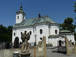
Notable landmarks include Catholic baroque John the Baptist church from 1746, old apothecary shop built around 1900 and the Polish school.
Part of the Olza River with its alluvium and surroundings from Dětmarovice to Bohumín (especially in Věřňovice) is an environment with fragile nature balance. In otherwise industrialized and densely populated area it is quite special, and hence is protected.
The village was host to an unexploded bomb from World War II, which remained in the village until being discovered in 2014. Resultantly, 400 residents were evacuated from their homes.