
Elevation 552 m Population 143 (2006) | Postal code 391 42 Area 4.47 km² | |
 | ||
Website | ||
20 let v ro robotick ho dojen lely vyso ina doln hrachovice
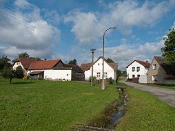
Dolní Hrachovice is a village and municipality (obec) in Tábor District in the South Bohemian Region of the Czech Republic.
Contents
- 20 let v ro robotick ho dojen lely vyso ina doln hrachovice
- Map of 391 43 DolnC3AD Hrachovice Czechia
- References
Map of 391 43 Doln%C3%AD Hrachovice, Czechia
The municipality covers an area of 4.47 square kilometres (1.73 sq mi), and has a population of 143 (as at 28 August 2006).
Dolní Hrachovice lies approximately 13 kilometres (8 mi) north-east of Tábor, 62 km (39 mi) north of České Budějovice, and 72 km (45 mi) south of Prague.
References
Dolní Hrachovice Wikipedia(Text) CC BY-SA