
County HertfordshireEssex Operation Manual Distance toBow Creek 18.3 miles (29.5 km) Length 26 m Waterway Lee Navigation | Maintained by British Waterways Fall 5 feet 1 inch (1.5 m) Distance toHertford Castle Weir 8.0 miles (12.9 km) Width 4.88 m | |
 | ||
Similar Waltham Common Lock, Carthagena Lock, Aqueduct Lock, Feildes Weir Lock, Hardmead Lock | ||
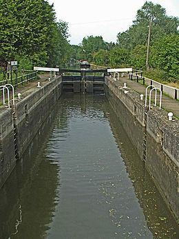
Dobbs Weir Lock (No 6) is a lock on the River Lee Navigation near Hoddesdon.
Contents
- Map of Dobbs Wier Lock Riverside Rd Nazeing Hoddesdon EN11 0BJ UK
- Location
- Public access
- Public transport
- References
Map of Dobbs Wier Lock, Riverside Rd, Nazeing, Hoddesdon EN11 0BJ, UK
Location
The lock is south of the nearby Dobbs Weir, and stands close to the confluence of the Lynch Brook and the Old River Lea. To the east of the lock is the Nazeing Mead complex of lakes which incorporates part of the River Lee Flood Relief Channel.
Public access
Vehicular access via Meadgate Road from Carthagena Lock.
Walking and cycle access along the towpath that forms part of the Lea Valley Walk.
Public transport
References
Dobbs Weir Lock Wikipedia(Text) CC BY-SA