
Area 19 ha | ||
 | ||
Biomes Northern hardwood forest, Waterfall, Swamp Similar Royalston Falls, Bear's Den, Mount Grace State For, Dexter Drumlin, Menemsha Hills | ||
Doane s falls
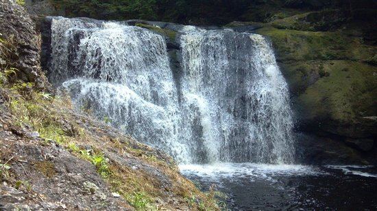
Doane's Falls is a series of five waterfalls located in Royalston, Massachusetts along an 0.2-mile (0.32 km) section of Lawrence Brook, a tributary of the Millers River. The falls are part of a 46-acre (19 ha) open space preserve acquired in 1959 by the land conservation non-profit organization The Trustees of Reservations. The 22-mile (35 km) Tully Trail passes through the property.
Contents
Map of Doane Falls, Royalston, MA, USA
The preserve is open to fishing, walking, picnicking, and hiking only; swimming and wading were banned in 2002 following a series of diving injuries and deaths. Canoeing and kayaking are allowed upstream from the falls along Coddings Meadow, a flatwater section of Lawrence Brook.
Doane's Falls are part of a larger contiguous area of protected open space, connected by the Tully Trail and including the United States Army Corps of Engineers' Tully Lake flood control project, The Trustees of Reservations' Jacobs Hill and Royalston Falls properties, and Massachusetts state forest land. Tully Lake Campground, a 35-site walk-in and tent only facility jointly managed by the Army Corps of Engineers and the Trustees of Reservations, abuts the west side of the Falls property.
A walk through doane s falls
History
Doane's Falls are named for Amos Doane, who operated a door, sash, and blind mill on Lawrence Brook in the 19th century. Doane's mill was one of several such ventures along the falls, of which only the foundations remain.