
Country Turkey Province Ağrı Province | Local time Saturday 9:14 AM | |
 | ||
Website www.dogubayazit-bld.gov.tr Weather 4°C, Wind E at 8 km/h, 74% Humidity | ||
Doğubayazıt is a district of Ağrı Province of Turkey, and it is the easternmost district of Turkey, bordering Iran. Its elevation is 1625m and its area is 2,383 km². Doğubayazıt's population in 2010 was 115,354 (up from 73,794 in 1980) of which 69,447 live in the town of Doğubeyazıt, the remainder in the surrounding countryside.
Contents
- Map of DoC49FubeyazC4B1t 04400 DoC49FubeyazC4B1t2FAC49FrC4B1 Turkey
- History
- Today
- Economy
- Places of interest
- Twin towns Sister cities
- References
Map of Do%C4%9Fubeyaz%C4%B1t, 04400 Do%C4%9Fubeyaz%C4%B1t%2FA%C4%9Fr%C4%B1, Turkey
The town of Doğubayazıt is a settlement with a long history. It lies 15 km southwest of Mount Ararat, 93 km east of the city of Ağrı and 35 km from the Iranian border. The town stands on a plain surrounded by some of Turkey's highest peaks including: Ararat (5,137m), Little Ararat (3,896m), Tendürek Dağı (3,533m), Kaletepe (3,196m) Arıdağı (2,934m) and Göllertepe (2,643m).
The climate on the plain is hot and dry in summer, cold and dry in winter.
History
For most of the periods described here, Doğubeyazıt was a bigger and more important settlement than the present-day provincial capital Ağrı, not least because this is the Iranian border crossing.
The area has had a rich history with monuments dating back to the time of the Kingdom of Urartu (over 2700 years ago). Before the Ottoman Empire the site was referred to by its Armenian name, Daroynk. In the 4th century the Sasanians failed to capture the Armenian stronghold and royal treasury at Daroynk. Princes of the Bagratid dynasty of Armenia resided at Daroynk and rebuilt the fortress into its present configuration with multiple baileys and towers carefully integrated into the ascending rock outcrop. When King Gagik Arcruni reoccupied the fortress ca.922 A.D. it became the seat of a bishop. It was subsequently conquered and reconquered by Persians, Armenians, Byzantines, and Seljuks all of whom would have used the plain to rest and recoup during their passages across the mountains. Turkish peoples arrived in 1064, but were soon followed by the Mongols and further waves of Turks. The castle of Daroynk was repaired many times throughout this history, although it is now named after the Turkish warlord Celayırlı Şehzade Bayazıt Han who ordered one of the rebuildings (in 1374). Ultimately, the town was renamed Beyazit itself in the 16th century.
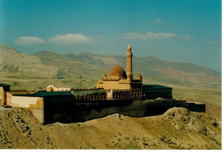
From the time of the Safavids, the area was ruled by Turkic-speaking generals, later including the Ottoman general İshakpaşa, who built the palace that still bears his name.
The town saw fighting in the Ottoman–Persian War (1821–23) when in 1821 commander-in-chief Abbas Mirza of Qajar Iran occupied the town, as well as when it was attacked by Russia later in 1856, and taken by the Russians during the Russo-Turkish War (1877–78). When the Russians retreated many of the Armenian population left with them to build New Beyazit (now Gavar at Armenia) on the shore of lake Sevan.
Doğubeyazıt was further ravaged during World War I and the Turkish War of Independence
The widely dispersed village of Bayazit, originally an Armenian settlement, was populated by Kurds in 1930 and Yazidis of Serhat Region, when the Turkish army destroyed it. A new town was built in the plain below the old site in the 1930s (hence the new name "Doğubeyazıt" which literally means "East Beyazıt").
Today
In January 2006, Doğubeyazıt was the centre of a H5N1 bird flu outbreak. Several children died from the disease after playing with chicken carcasses.
The Doğubayazıtspor football club plays in the lower divisions of the Turkish football league. It played in the Turkish Third League for three seasons.
Economy
Starting in 1920, the area began producing sulphur.
Places of interest
Twin towns — Sister cities
Doğubeyazıt is twinned with: