
Country Algeria Elevation 1,035 m (3,396 ft) ONS code 3302 Local time Thursday 3:23 AM Postal code 33100 | District Djanet (seat) Time zone CET (UTC+01) Area 57,460 km² Population 14,655 (2008) | |
 | ||
Weather 16°C, Wind N at 18 km/h, 31% Humidity | ||
We found love algeria djanet
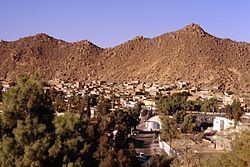
Djanet (Arabic: جانت) is an oasis city, and capital of Djanet District, in Illizi Province, southeast Algeria. It is located 412 km (256 mi) south of the provincial capital, Illizi. According to the 2008 census it has a population of 14,655, up from 9,699 in 1998, and an annual population growth rate of 4.3%. It is inhabited by the Kel Ajjer Tuareg people.
Contents
- We found love algeria djanet
- Map of Djanet Algeria
- History
- Geography
- Climate
- Transport
- Education
- Localities
- References
Map of Djanet, Algeria
History
The region of Djanet has been inhabited since Neolithic times. There were periods of ten thousand years at a time that the area was not desert. The flora and fauna were luxuriant as is seen in the numerous rock paintings of Tassili n'Ajjer around Djanet. Populations of hunter-gatherers lived there.
Djanet was founded in the Middle Ages by the Tuareg. The Ottoman Empire, which had a nominal authority over the Fezzan region, reinforced their presence in the area at the beginning of the 20th century in reaction to the colonization of Africa by the Europeans.
Geography
Djanet, and the nearby towns of Azelouaz, El Mihan, Adjahil and Eferi, lie in a valley carved by the intermittent river (wadi) Oued Idjeriou through the southwest edge of the Tassili n'Ajjer mountain range. The Tadrart Rouge is located to the southeast and is a southern prolongation of the Libyan Tadrart Acacus.
Due to the somewhat cooler air, higher humidity and somewhat higher rainfall in these areas, the nearby mountains support a greater amount and variety of wildlife than lower-lying areas in the Sahara, and forms part of the West Saharan montane xeric woodlands ecosystem. Djanet itself lies at an altitude of 1,035 metres (3,396 ft), but the mountains to the east and north reach as high as 1,905 metres (6,250 ft).
Climate
Djanet has a hot desert climate (Köppen climate classification BWh), with very hot summers and mild winters. The city is extremely dry throughout the year, with an annual average rainfall of just 14.6 millimetres (0.57 in) and no month with an average of more than 3 millimetres (0.12 in).
Transport
Djanet Inedbirene Airport is located about 50 kilometers south of the city center.
Education
4.1% of the population has a tertiary education, and another 19.8% has completed secondary education. The overall literacy rate is 85.6%, and is 92.1% among males and 78.0% among females, all three rates being the highest for any commune in the province.
Localities
The commune is composed of 12 localities: