
Country Tajikistan ISO 3166 code TJ-RR Population 1.723 million (2010) | Capital Dushanbe Area 28,600 km² | |
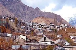 | ||
Clubs and Teams CSKA Pamir Dushanbe, Varzob Dushanbe Points of interest Dushanbe Flagpole, Dushanbe Zoo, Botanical Garden, Rudaki Park, Hisor Fortress Colleges and Universities Tajik National University, Russian‑Tajik Slavonic University, Tajik State Medical University, Tajik State University of Comm, Agricultural University of Tajikist | ||
Districts of Republican Subordination (Tajik: Ноҳияҳои тобеи ҷумҳурӣ, Nohiyaho‘i tobe‘i jumhurî/Nohijahoji toвeji çumhurī; Persian: ناحیه های تابع جمهوری, Nâhiyehâ'i tâb'e jomhuri; Russian: Районы республиканского подчинения, Rajony respublikanskogo podčinenija) is a region in Tajikistan, consisting of 13 districts which are directly under central rule.
Contents
- Map of Districts of Republican Subordination Tajikistan
- History
- Districts
- West Karotegin
- Dushanbe City
- Central Karotegin
- East Karotegin Rasht Valley
- Geography
- References
Map of Districts of Republican Subordination, Tajikistan
History
The Districts of Republican Subordination cover much of the territory of the Gharm Oblast which was dissolved in 1955.
The district was formerly known as Karotegin Region.
Districts
The 13 districts are listed below roughly in their order of occurrence from west to east within the band forming the Region of Republican Subordination. The order of the districts and the district names are based on two consistent sources: an administrative map of Tajikistan and a statistical yearbook showing the breakdown of RRP into districts.
West Karotegin
Dushanbe City
Central Karotegin
East Karotegin (Rasht Valley)
Geography
The plateau is traversed by the Vakhsh River, a right-hand tributary of the Amu Darya. On the northern border run the Gissar and Zeravshan mountains, and on the southern border the Darvaz range 7,600 metres (24,900 ft) . The area is 28,400 square kilometres (11,000 sq mi). The winter climate is extremely severe; snow begins to fall in October and it is May before it disappears. During the warmer months, however, the mountainsides are richly clothed with the foliage of maple, mountain ash, apple, pear and walnut trees; the orchards furnish, not only apples and pears, but peaches, cherries, mulberries and apricots. Both cattle and horses are of a small and hardy breed.