Suvarna Garge (Editor)

Districts of New Zealand

Updated on
Edit
Like
Comment
Share on FacebookTweet on TwitterShare on LinkedInShare on Reddit
Districts of New Zealand

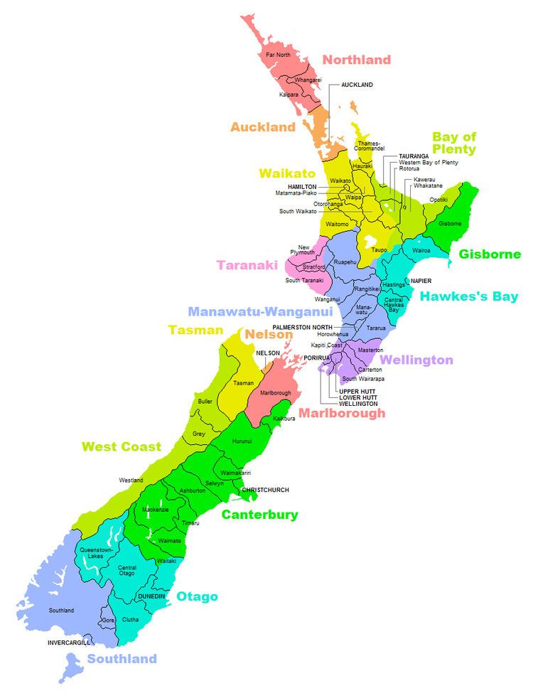
A district in New Zealand is a territorial authority area governed by a District Council as a second-tier local government unit. They were formed as a result of local government reforms in 1989.

Contents

Districts

There are currently 53 districts:

Bay of Plenty Region

  • Kawerau District
  • Opotiki District
  • Western Bay of Plenty District
  • Whakatane District
  • Hawke's Bay Region

  • Central Hawke's Bay District
  • Hastings District
  • Wairoa District
  • Manawatu-Wanganui Region

  • Horowhenua District
  • Manawatu District
  • Ruapehu District
  • Whanganui District
  • Northland Region

  • Far North District
  • Kaipara District
  • Whangarei District
  • Taranaki Region

  • New Plymouth District
  • South Taranaki District
  • Waikato Region

  • Hauraki District
  • Matamata-Piako District
  • Otorohanga District
  • South Waikato District
  • Thames-Coromandel District
  • Waikato District
  • Waipa District
  • Wellington Region

  • Carterton District
  • Kapiti Coast District
  • Masterton District
  • South Wairarapa District
  • Mixed

  • Rangitikei District (Manawatu-Wanganui: 86.37%; Hawke's Bay: 13.63%)
  • Rotorua District (Bay of Plenty: 61.52%; Waikato: 38.48%)
  • Stratford District (Taranaki: 68.13%; Manawatu-Wanganui: 31.87%)
  • Tararua District (Manawatu-Wanganui: 98.42%; Wellington: 1.58%)
  • Taupo District (Waikato: 73.74%; Bay of Plenty: 14.31%; Hawke's Bay: 11.26%; Manawatu-Wanganui: 0.69%)
  • Waitomo District (Waikato: 94.87%; Manawatu-Wanganui: 5.13%)
  • Unitary authorities

  • Gisborne District
  • Canterbury Region

  • Ashburton District
  • Hurunui District
  • Kaikoura District
  • Mackenzie District
  • Selwyn District
  • Timaru District
  • Waimakariri District
  • Waimate District
  • Otago Region

  • Central Otago District
  • Clutha District
  • Queenstown-Lakes District
  • Southland Region

  • Grey District
  • Southland District
  • West Coast Region

  • Buller District
  • Gore District
  • Westland District
  • Mixed

  • Waitaki District (Canterbury: 59.61%; Otago: 40.39%)
  • Unitary authorities

  • Marlborough District
  • Tasman District
  • Notes:

  • Kaikoura District was transferred from the Nelson-Marlborough Region to the Canterbury Region in 1992.
  • Banks Peninsula District became part of Christchurch as a result of 2005 referendum.
  • Franklin District, Papakura District and Rodney District no longer exist as of 2010. They became part of other districts and Auckland Region.
  • References

    Districts of New Zealand Wikipedia