
Country Philippines Founded 1865 Time zone PST (UTC+8) Local time Wednesday 5:30 AM | District 1st District Barangays Area 92.52 km² Province Bataan | |
 | ||
Region Central Luzon (Region III) Weather 23°C, Wind N at 3 km/h, 86% Humidity University University of Nueva Caceres - Bataan Neighborhoods Pinulot, Luacan, Naparing, Tucop, Saguing | ||
Dinalupihan, officially the Municipality of Dinalupihan (Filipino: Bayan ng Dinalupihan; Kapampangan: Balen ning Dinalupihan), is a municipality in the province of Bataan in the Central Luzon (Region III) of the Philippines. The population was 106,371 at the 2015 census. In the 2016 electoral roll, it had 62,848 registered voters. It is the only landlocked town of the province.
Contents
- Map of Dinalupihan Bataan Philippines
- Etymology
- Geography
- Barangays
- Demographics
- Government
- Attractions
- Notable people
- References
Map of Dinalupihan, Bataan, Philippines
Dinalupihan is accessible via the Bataan Provincial Expressway, off Exit 5.
Etymology
"Dinalupijan" came from the festival rights of "Aeta" pygmies. To commemorate their idol "Indianalo", the goddess of hunting and bountiful harvest."Indianalo" was paired with the Sanskrit word "jann", meaning paradise. "Indianalopijann" was the name given to the land that the "Aetas" received from their goddess which translates to Indianalo's paradise. As time progresses, the name "Indianalopijann" turned into "Dinalupihan".
The name "Dinalupihan" also means "empty lands", coming from the Spanish terms din, a, and lupia. It referred to the fact that it failed to produce little revenue while it was an estate of the Archdiocese of Manila during the second half of the 18th century.
Geography
Dinalupihan is located at 14°53′N 120°28′E.
According to the Philippine Statistics Authority, the municipality has a land area of 92.52 square kilometres (35.72 sq mi) constituting 7000674000000000000♠6.74% of the 1,372.98-square-kilometre- (530.11 sq mi) total area of Bataan.
Barangays
Dinalupihan is politically subdivided into 46 barangays.
Demographics
In the 2015 census, Dinalupihan had a population of 106,371. The population density was 1,100 inhabitants per square kilometre (2,800/sq mi).
In the 2016 electoral roll, it had 62,848 registered voters.
Government
Pursuant to the Local government in the Philippines", the political seat of the municipal government is located at the Municipal Town Hall. In the History of the Philippines (1521–1898), the Gobernadorcillo was the Chief Executive who held office in the Presidencia. During the American rule (1898–1946) (History of the Philippines (1898-1946)), the elected Mayor and local officials, including the appointed ones hold office at the Municipal Town Hall. The legislative and executive departments perform their functions in the Sangguniang Bayan (Session Hall) and Municipal Trial Court, respectively, and are located in the Town Hall.
Dinalupihan, Bataan's incumbent Mayor is Gila Garcia (NUP) and the Vice Mayor is Renato Matawaran (AKSYON).
Sangguniang Bayan Members are: Ricardo De Ausen, Martin Tongol Jr., Danny Dela Cruz, Rolly Buniag, Amy Sandoval, Zaldy Torno, Maning Inza Cruz, Arnold Soriano, ABC Armando Buniag and SK Ernest Estanislao.
Attractions
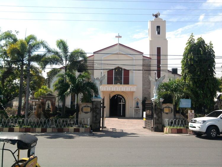
Dinalupihan's interesting points, landmarks and festivals, are:
Saint John the Baptist Parish Church (in Poblacion) belongs to the Roman Catholic Diocese of Balanga (Dioecesis Balangensis) Suffragan of San Fernando, Pampanga Created: March 17, 1975. Canonically Erected: November 7, 1975. Comprises the whole civil province of Bataan. Titular: St. Joseph, Husband of Mary, April 28. Bishop Most Reverend Ruperto Cruz Santos, DD).
Its Feast day is June 24. It is under the Vicariate of Saint Peter of Verona I - Vicariate of Our Lady, Mirror of Justice. The Catholic population is about 25,438.