
Country Serbia Settlements 43 Time zone CET (UTC+1) Local time Tuesday 9:55 PM | Elevation 545 m (1,788 ft) Area 483 km² | |
 | ||
Weather 9°C, Wind E at 10 km/h, 76% Humidity | ||
Dimitrovgrad (Serbian Cyrillic: Димитровград) is a town and municipality located in the Pirot District of the eastern Serbia. According to 2011 census, the municipality of Dimitrovgrad has a population of 10,118 people and the town 6,278.
Contents
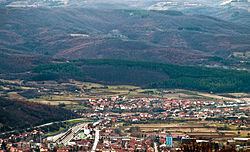
Map of Dimitrovgrad, Serbia
Name
The official Serbian name is Dimitrovgrad (Димитровград), but the name Caribrod (Цариброд) is also used in Serbian. In Bulgarian, the name Tsaribrod (Цариброд) is preferred because there is another town called Dimitrovgrad on the Maritsa river in Bulgaria and Tsaribrod was used before the town was named after Georgi Dimitrov, a Bulgarian Communist leader who advocated a union between the Bulgarians and remaining Yugoslav nations to form the Balkan Federation. The idea was abandoned when Yugoslav leader Josip Broz Tito failed to reach agreements with Joseph Stalin (Tito-Stalin split), however Dimitrov himself did not become unpopular in Yugoslavia from the breakdown and subsequently, the name of the town continued to be in honour of him despite many Bulgarians themselves having preferred Caribrod.
There have been attempts to return the old name, Caribrod, but the last referendum, held on Sunday, June 13, 2004, was invalid due to a low turnout. Only 47.8% of the 9,811 voters on the electoral roll turned out to vote, while 50% was the required minimum. Of those who voted on the issue, 2,586 were in favour of keeping the name Dimitrovgrad, while 1,786 wanted the name Caribrod to be returned.
History
The Roman road Via Militaris was built in the 1st century AD and went through the town. In May 2010, well-preserved remains of the road were excavated during the work on Corridor 10.
An Ottoman military base operated in the west of Dimitrovgrad prior to the Balkan nations full independence.
The Serbian and Bulgarian Prime ministers met at the then Tsaribrod in 1912 to discuss the disputed territories in Macedonia. The Kingdom of Serbs, Croats and Slovenes gained parts of the Principality of Bulgaria (known in Bulgaria as Western Outlands) which included Tsaribrod following the Treaty of Neuilly, signed on November 27, 1919.
From 1929 to 1941, Caribrod was part of the Morava Banovina of the Kingdom of Yugoslavia. It was occupied by Kingdom of Bulgaria between 1941 and 1944 during World War II.
Demographics
According to the 2011 census results, the municipality has 10,118 inhabitants.
Ethnic groups
Regardless of ethnic self-identification, most of the town's population speaks a South Slavic dialect usually called Torlak which includes linguistic features of both Serbian (especially phonology) and Bulgarian (postposed definite articles and lack of the infinitive verb form), as well as some entirely unique vocabulary.
Ethnic composition of the municipality: