
 | ||
Module 1 introduction to digital soil mapping
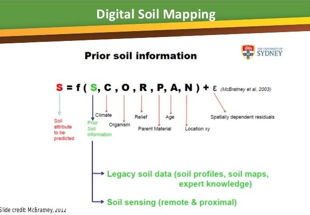
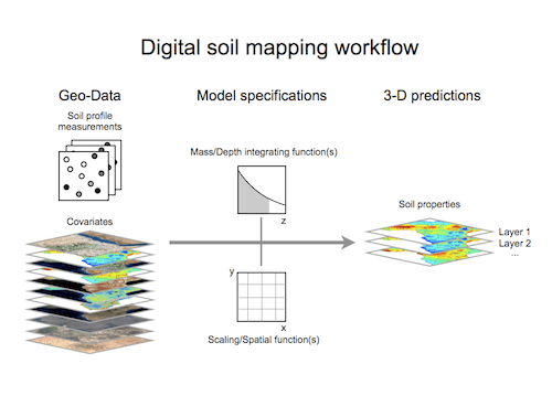
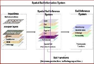
Digital Soil Mapping (DSM) in soil science, also referred to as predictive soil mapping or pedometric mapping, is the computer-assisted production of digital maps of soil types and soil properties. Soil mapping, in general, involves the creation and population of spatial soil information by the use of field and laboratory observational methods coupled with spatial and non-spatial soil inference systems.
Contents
- Module 1 introduction to digital soil mapping
- Digital soil mapping and automated landform classification
- Ambiguities
- References
The international WORKING GROUP ON DIGITAL SOIL MAPPING (WG-DSM) defines digital soil mapping as "the creation and the population of a geographically referenced soil databases generated at a given resolution by using field and laboratory observation methods coupled with environmental data through quantitative relationships."
Digital soil mapping and automated landform classification
Ambiguities
DSM can rely upon, but is considered to be distinct from traditional soil mapping, which involves manual delineation of soil boundaries by field soil scientists. Soil maps (paper sheets) produced as result of manual delineation of soil mapping units may also be digitized or surveyors may draw boundaries using field computers, hence both traditional, knowledge-based and technology and data-driven soil mapping frameworks are in essence digital. Unlike traditional soil mapping, Digital Soil Mapping is, however, considered to make an extensive use of:
- technological advances, including GPS receivers, field scanners, and remote sensing, and
- computational advances, including geostatistical interpolation and inference algorithms, GIS, digital elevation model, and data mining
In digital soil mapping, semi-automated techniques and technologies are used to acquire, process and visualize information on soils and auxiliary information, so that the end result can be obtained at cheaper costs. Products of the data-driven or statistical soil mapping are commonly assessed for the accuracy and uncertainty and can be more easily updated when new information comes available.
Digital Soil Mapping tries to overcome some of the drawbacks of the traditional soil maps that are often only focused on delineating soil-classes i.e. soil types. Such traditional soil maps: