
Time zone UTC -3 Dial plan +598 4474 (+4 digits) Local time Tuesday 6:41 AM | Postal code 27101 Climate Cfa Population 977 (2011) | |
 | ||
Weather 19°C, Wind SW at 6 km/h, 93% Humidity | ||
Dieciocho de Julio or 18 de Julio is a small town in the Rocha Department of southeastern Uruguay.
Contents
- Map of 27101 Dieciocho de Julio Rocha Department Uruguay
- Location
- History
- Population
- Features
- Fuerte San Miguel
- References
Map of 27101 Dieciocho de Julio, Rocha Department, Uruguay
Location
The town is located about9 kilometres (5.6 mi) west of Chuy along Route 19. The next village to its west is San Luis al Medio.
History
On 12 June 1909, the populated centre known as "San Miguel" was renamed and declared a "Pueblo" (village) by the Act of Ley N° 3.495. Its status was elevated to "Villa" (town) on 20 June 1961 by the Act of Ley Nº 12.876.
Population
In 2011 18 de Julio had a population of 977.
Source: Instituto Nacional de Estadística de Uruguay
Features
In the town, there is the Fortin de San Miguel, a castle which has been converted to an inn and hotel.
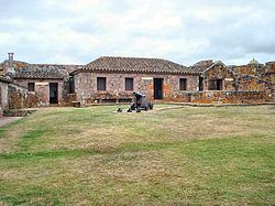
Fuerte San Miguel
At the east end of the town is a hill on which the Fuerte San Miguel is situated, a prominent fort during colonial times, built in 1737 by the Portuguese. Between the fort and the town is also the Criollo Museum, which displays outdoors replicas of the life of the gauchos, as well as indoors exhibits of the carts and carriages of the times.