
Country Italy Time zone CET (UTC+1) Area 6.5 km² | Demonym(s) Dianesi Postal code 18013 Local time Tuesday 1:05 AM | |
 | ||
Frazioni Diano Calderina, Diano Serreta, Diano Gorleri, borgata Muratori Weather 12°C, Wind N at 31 km/h, 44% Humidity | ||
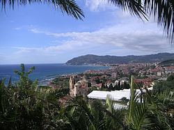
Diano Marina is a comune (municipality) in the Province of Imperia in the Italian region Liguria, located about 90 km southwest of Genoa and about 5 km northeast of Imperia. As of 31 December 2004, it had a population of 6,199 and an area of 6.5 km².
Contents
- Map of 18013 Diano Marina Province of Imperia Italy
- Geography
- History
- Twin towns Sister cities
- References
Map of 18013 Diano Marina, Province of Imperia, Italy
Geography
The municipality of Diano Marina contains the frazioni (subdivisions, mainly villages and hamlets) Diano Calderina, Diano Serreta, Diano Gorleri, Diano Arentino, Diano san Pietro and borgata Muratori.
Diano Marina borders the following municipalities: Diano Castello, Imperia, and San Bartolomeo al Mare.
Diano Marina is one of the few municipalities along the Ligurian coast with long sandy beaches. The beach season is from May 15 until September 15. Outside of the beach season most of the beaches are accessible to the public.
Diano Marina is also known for its streets lined with orange trees and is referred to as the "Citta degli aranci" (City of the orange trees).
History
In the year 1508 Diano Marina was attacked and the town was partly destroyed by Ottoman forces under Curtogoli.
Twin towns — Sister cities
Diano Marina is twinned with: