
Country India District Barabanki Time zone IST (UTC+5:30) Elevation 137 m Local time Wednesday 2:01 AM | State Uttar Pradesh Founded by Hazi Waris Ali Shah PIN 225301 Population 12,819 (2001) Area code 05248 | |
 | ||
Weather 17°C, Wind NE at 3 km/h, 55% Humidity | ||
Dewa Sharif Hindi: देवा शरीफ़, Urdu: دیوا شریف) is a town in Barabanki district in the state of Uttar Pradesh, India. It is a Block, Development Block, Police station(Thana) and Nagar Panchayat It is the town of Barabanki.
Contents
- Map of Dewa Uttar Pradesh 225301
- Geography
- Block Panchayat Dewa
- Road connectivity
- Religious shrine and structures
- References
Map of Dewa, Uttar Pradesh 225301
The State Government has notified Dewa Sharif of District Barabanki under the linguistic minority population where speakers of Urdu constitute 15 per cent or more of the local population. It was placed as one among the prominent sites in Heritage Arc of U.P.
Geography
Dewa Sharif has an average elevation of 110 metres (360 feet).
Block Panchayat Dewa
Block Panchayat Dewa Sharif has 67 Village Panchayats, they are,:
Road connectivity
Dewa Sharif has a very good road connectivity from Lucknow, Barabanki, Fatehpur, Kursi, Masauli, Cinhat. It has a regular bus service from Lucknow and Barabanki which go en route through town stopping of 15 minute all over day initial service from 5:30 a.m. to 9:00 p.m.
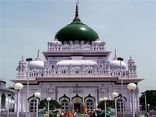
Religious shrine and structures
Dewa Sharif is famous for the shrine of Haji Waris Ali a sufi saint with his followers throughout India and throughout the world, with many being from Europe.The shrine is visited by piligrims from throughout the world.