
Elevation 1,920 m | Prominence 1,920 m | |
 | ||
First ascent Alfred Herbert Joy and party, 1926 Similar Qiajivik Mountain, Bishop's Mitre, Midnight Sun Peak, Osborn Range | ||
Devon ice cap shrinking time lapse devon island nu canada
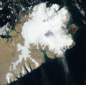
The Devon Ice Cap is an ice cap on eastern Devon Island, Nunavut, Canada, covering an area of over 12,000 km2 (4,600 sq mi). The highest point on Devon Island is found at the summit of the ice cap, with an elevation of 1,920 m (6,299 ft). The ice cap has a maximum thickness of 880 m (2,887 ft), and has been steadily shrinking since 1985.
Contents
- Devon ice cap shrinking time lapse devon island nu canada
- Map of Devon Ice Cap Baffin Unorganized NU Canada
- References
Map of Devon Ice Cap, Baffin, Unorganized, NU, Canada
The first ascent of the Devon Ice Cap was by Alfred Herbert Joy and his Inuit companions in 1926.
References
Devon Ice Cap Wikipedia(Text) CC BY-SA