
Parent range Channel Islands Elevation 740 m | Prominence 747 m | |
 | ||
Similar Mount Orizaba, Fremont Peak, Olancha Peak, Mount Ansel Adams, Mount Abbot | ||
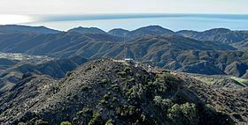
Devils Peak (or Mount Diablo) at 2,429 feet (740 m) is the tallest peak on the Channel Islands of California. It is located on Santa Cruz Island within Channel Islands National Park on land owned by The Nature Conservancy. Visiting the area requires a permit.
Map of Devils Peak, California 93001, USA
Devil's Peak is the highest mountain on an ocean island in the contiguous 48 states, edging out Mount Constitution on Orcas Island by a few feet.
References
Devils Peak (Santa Barbara County, California) Wikipedia(Text) CC BY-SA