
Lake type eutrophic Catchment area 12 sq mi (31 km) Max. length 3 mi (4.8 km) Area 2.752 km² | Basin countries United States Surface elevation 3.17 m Length 4.828 km | |
 | ||
Primary inflows Similar Roads End State Recreatio, D River State Recreatio, Chinook Winds Casino, Regatta Park, Fogarty Creek State Rec | ||
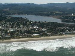
Devils Lake is a small lake in Lincoln County, Oregon, United States, along the Oregon Coast. It separates the northern part of Lincoln City from the Central Oregon Coast Range. It is 1/3 of a mile wide, three miles (5 km) long, and up to 21 feet (6.4 m) deep. The D River flows from the lake westward to the Pacific Ocean. At 120 feet (37 m), it is one of the world's shortest rivers.
Map of Devils Lake, Oregon, USA
According to Oregon Geographic Names, the name derives from a Native American legend. In the legend, a giant fish or other large marine creature would occasionally surface, much to the dismay of anyone fishing in the vicinity.
The lake is managed by the Devils Lake Water Improvement District. The Preservation Association of Devils Lake (PADL) was founded in 1982. According to the organization's website, its mission is:
To correct, protect and preserve the water resources and other natural assets of Devils Lake from misuse and pollution. To encourage the improvement of the overall environmental and economic use of the lake as a recreational, scenic asset for all time to the entire Lincoln City area.