
Elevation 1,167 m | ||
 | ||
Topo map USGS Snowy Mountain, Monterey Mountain range Ridge-and-Valley Appalachians Parent range Ridge-and-Valley Appalachians | ||
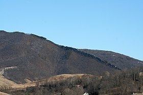
Devils Backbone (also Devil's Backbone) is a ridge and rock outcrop located in Highland County, Virginia, United States. The ridge is located approximately 7.6 miles (12.2 km) north-northeast of Monterey, Virginia near the village of Blue Grass.
Map of Devils Backbone, Blue Grass, VA 24413, USA
Along the crest of the ridge line is a near vertical outcrop of Tuscarora Sandstone approximately 84 feet (26 m) thick. This formation gives the ridge its name of Devils Backbone, as the outcrop has been described "like the vertebrae of some monstrous prehistoric animal". The formation has also been described as resembling that of "the comb on the head of a domestic fowl".
References
Devils Backbone (Highland County, Virginia) Wikipedia(Text) CC BY-SA