
 | ||
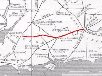
The Devil's Highway was a Roman road in Britain connecting Londinium (London) to Pontes (Staines) to Calleva Atrebatum (Silchester). The bridges at Pontes probably crossed Church Island. At Calleva, the road split into three routes west: the Port Way to Sorviodunum (Old Sarum), Ermin Way to Glevum (Gloucester), and the road to Aquae Sulis (Bath).
The London portion of the road was rediscovered during Christopher Wren's rebuilding of St Mary-le-Bow's in 1671–73, following the Great Fire. Modern excavations date its construction to winter from AD 47 to 48. Around London, it was 7.5–8.7 metres (25–29 ft) wide and paved with gravel. It was repeatedly redone, including at least twice before the sack of London by Boudica's troops in 60 or 61. The road ran straight from the bridgehead on the Thames to what would become Newgate on the London Wall before passing over Ludgate Hill and the Fleet, separating into the Devil's Highway and the northwest stretch of Watling Street, going on to Verulamium (St Albans).