
- average 396 cu ft/s (11.2 m/s) Discharge 11.21 m³/s Basin area 419.6 km² | - min 48 cu ft/s (1.4 m/s) Length 80 km Basin area 419.6 km² Country United States of America | |
 | ||
- max 8,150 cu ft/s (230.8 m/s) Source Gifford Pinchot National Forest | ||
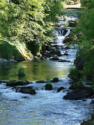
The Deschutes River is a 50-mile (80 km)-long river in Washington, United States. Its source is in the Gifford Pinchot National Forest in Lewis County, and it empties into Budd Inlet of Puget Sound at Olympia in Thurston County. It was given its name by French fur traders, who called it Rivière des Chutes, or "River of the Falls," a translation of the First Nations name for the site. (The city of Tumwater, founded in the same location, takes its name from another translation for "waterfall", this one in Chinook Jargon.)
Map of Deschutes River, Washington, USA
It is famous for the brewery which was located there from 1896 until Prohibition. The Olympia Brewing Company bought the brewery after Prohibition ended in 1933. (Today it is owned by SABMiller, but is no longer operational.)
The river has numerous parks along it, including Pioneer Park and Tumwater Falls Park. A popular tubing stretch runs from Pioneer Park to Tumwater Falls.
A small tributary of the Deschutes River is Lake Lawrence, a 339-acre (1.37 km2) spring-fed residential and fishing lake approximately equidistant from the communities of Yelm to the northwest, and Rainier to the west.